
0
On this tour, you will be treated to breathtaking views, local history and fascinating stories. Experience unique sights, hidden gems and natural contrasts, while listening to stories about the people and places that make the route memorable. Enjoy the journey and the impressions! Press “DOWNLOAD” and then “START” to begin the tour. You can listen to the audio guide now while you are there, or download it to listen later – anywhere.

Looking towards land, we now see Molja Lighthouse, guiding sailors safely home since 1858. Remarkably, this area contains some of the few buildings that escaped the devastating flames of Ålesund’s great fire of 1904, when almost the entire town was reduced to ashes. Here you'll find the Fisheries Museum, located in authentic maritime warehouses dating from the mid-1800s. The museum provides fascinating insights into Ålesund’s proud maritime heritage and the vital role fishing has played in the city’s history. Close by is Teaterfabrikken, a vibrant cultural venue housed in rustic, original premises, famous for its informal atmosphere and lively performances. Originally built as a factory in the 19th century, the building tells the story of Ålesund’s industrial past, long before Art Nouveau became the city’s hallmark. Together, these locations form an authentic time capsule, offering a glimpse into old Ålesund and standing as living reminders of how the city appeared before the catastrophe shaped its unique urban landscape of today.

Bienvenue à Geiranger ! Parfois, les mots ne suffisent pas et là, c’est le cas. Geiranger ne peut pas être décrit, il doit être vécu ! Le petit village du fjord entouré de montagnes escarpées, de rivières dansantes et de cascades majestueuses surpasse la plupart des aventures Disney. Et nous ne sommes pas les seuls à être de cet avis ! Peu d’endroits figurent sur autant de listes des plus belles destinations du monde que Geiranger. Les gens vivent ici depuis l’âge de pierre, et aujourd’hui, près d’un million de touristes rendent visite chaque année au cours des mois d’été trépidants aux quelques centaines de résidents permanents du village. Ici, vous pouvez vous promener dans le petit centre-bourg composé d´abris de bateaux et de vieilles maisons en bois, déguster un café ou une glace, ou goûter le chocolat et la bière de Geiranger. Aventurez-vous plus loin sur la promenade qui jouxte la cascade Storfossen et mène au Norsk Fjordsenter – “Le Centre Norvégien des Fjords” et au légendaire Hôtel Union. Et une fois que vous aurez commencé, vous ne pourrez plus vous arrêter, tant il y a de visites culturelles et historiques et d’activités dans la nature qui n’attendent que vous, que ce soit en bateau, en voiture, en bus, à vélo ou à pied !

Il n’est pas difficile de comprendre pourquoi les gens sont aveuglés par la nature splendide qu’ils rencontrent ici dans le fjord. Cependant, quelque chose se passe lorsque l’obscurité survient ou lorsqu’une brume épaisse se déploie comme une couverture opaque entre les flancs de la montagne. À ce moment-là, les mythes et légendes sur les huldres, les trolls, les serpents de mer et les nisses prennent vie. Ce sont les histoires traditionnelles de ces régions, et beaucoup de contes ont leurs racines dans les communautés locales et continuent de passionner les enfants et les touristes. À Valldal, plus loin dans le fjord, la légende raconte qu’Olav le Saint, alors qu’il ramait dans ces fjords, rencontra un énorme serpent de mer. Ce fut une véritable lutte, mais après un dur combat, Olav vainquit le serpent et le jeta sur la paroi rocheuse avec une telle force que le serpent resta coincé dans la pierre. Son empreinte demeure encore aujourd’hui. Les flancs de montagnes escarpés et couverts de sapins ont créé au fil du temps d’étranges formes qui ont nourri l’imagination vive des gens. Juste là où nous passons maintenant, vous pouvez voir des trolls sur la paroi rocheuse même en plein jour. Essayez ! Et nous n’osons même pas vous dire ce que vous pouvez voir la nuit !

Can you smell it? The fresh, salty sea air mixed with the scent of fish? In Ålesund, we like to say that this is the smell of money, and with good reason: The entire history and wealth of the city is built on the fish from the sea. Now we pass Aspøya and Skarbøvika, both outer districts of Ålesund, where several of Norway's largest exporters of seafood are located. From these quays, large quantities of fish are shipped out into the world every day, everything from fresh salmon – one of Norway's most important exports – to traditional whitefish such as cod and saithe. But perhaps best known of all is herring, the "silver of the sea", which historically made Ålesund one of the country's richest cities. As early as the early 20th century, fishermen flocked here to hunt for huge shoals of herring, and the city quickly became a center for herring fishing and export. Today, modern fish factories continue this legacy, with advanced technology that ensures that the fish is delivered fresh and of top quality to customers all over the world. When you smell the sea and fish, you also smell the scent of Ålesund's history, culture and prosperity.

Peu d’endroits peuvent séduire avec une nature si belle et si bien préservée. Et pour cette raison, le Geirangerfjord figure sur la liste prestigieuse du patrimoine mondial de l’UNESCO. Ici, vous trouverez également les points de vue les plus impressionnants de Norvège, quelle que soit la route par laquelle vous arrivez à Geiranger. Du centre du village, vous pourrez suivre la route qui traverse la vallée et mène à deux d’entre eux, 
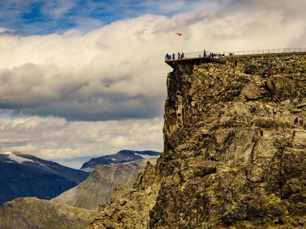
Flydalsjuvet et Geiranger Skywalk à Dalsnibba. Flydalsjuvet se trouve au milieu de la vallée et est équipé de plateformes et de bancs permettant aux visiteurs d’admirer en contrebas la splendeur du Geirangerfjord, sur lequel les navires de croisière ressemblent d’ici à des bateaux miniatures. De là, vous pourrez également apercevoir plusieurs centaines de mètres plus bas la rivière Maråk qui descend la vallée jusqu’au centre de Geiranger. Tout en haut, vous trouverez le magique Geiranger Skywalk à Dalsnibba, à 1500 mètres d’altitude. De là, vous profiterez de la vue sur le fjord la plus haute et la plus belle d’Europe. La plateforme est construite à flanc de montagne, et avec une chute libre de 500 mètres sous vos pieds, vous avez l’impression de marcher sur les nuages, même si, bien sûr, vous êtes parfaitement en sécurité. Tous ces points de vue se trouvent sur l’une des « routes touristiques nationales » du pays, qui ont pour but de renforcer le tourisme en Norvège.

Voyez-vous la route serpenter sur le flanc escarpé de la montagne ? C’est Ørnevegen – “La Route de l’Aigle”, aujourd’hui « route touristique nationale », qui emmène les automobilistes en direction du petit village de Eidsdal, à travers 11 virages en épingle à cheveux jusqu’à son point le plus élevé à 620 mètres au-dessus du niveau de la mer. La route a été officiellement ouverte en 1955 et a donné à Geiranger un accès routier à l’année très attendu. Elle tire son nom du fait qu’à son point culminant, elle traverse un terrain qui était le domaine d’un grand nombre d’aigles. Aujourd’hui, les aigles avec leur énorme envergure planent majestueusement haut dans les airs en observant les touristes ! Dès le premier jour, les automobilistes ont été fascinés par la belle vue qui s’est révélée en haut de la route. Bientôt, les voyageurs de toute la Norvège se sont arrêtés dans les virages pour profiter du panorama extraordinaire et peu de temps après, les touristes d’Europe et du monde entier ont fait leur entrée en moto, en voiture, en camping-car et en bus. Les autorités ont progressivement facilité les accès aux touristes et amélioré la sécurité routière en réglementant et en prolongeant le virage en épingle à cheveux supérieur. Il porte le nom de Ørnesvingen – “Le Virage de l’Aigle” et est peut-être le belvédère le plus célèbre de Norvège. Aujourd’hui, les touristes peuvent se promener sur un sol en verre, d’où ils peuvent voir le fjord sous leurs pieds tout en ayant une vue panoramique sur le village de Geiranger et les cascades des Sept Sœurs. Peut-être peuvent-ils même voir les trolls dans la paroi rocheuse de l’autre côté du fjord. Et vous, le pouvez-vous ?

On April 9, 1940, the alarm went off in Norway, and five long years of war followed. Now we pass Tueneset Coastal Fort, an important part of the extensive defenses that the occupying forces built around Ålesund. The harbor here was strategically very important, and served as one of Germany's largest convoy ports along the Norwegian coast. To protect the ships from Allied attacks, gun emplacements, bunkers and observation posts were built. The fort was to withstand any attacks from the sea and ensure safe traffic into Ålesund harbor. Today, Tueneset Coastal Fort stands as a strong historical monument from World War II. Volunteer forces have transformed the area into a museum and open-air recreation area where you can explore bunkers, gun emplacements and other traces of the war, while enjoying the beautiful view of the sea. Here you can walk around and get a unique insight into local history, while the area invites you to reflect on a dramatic period in Norway's past. On the other side of the fjord we see Godøya, which belongs to the neighboring municipality of Giske. The island is known for its beautiful nature, nice beaches and popular hiking areas with fantastic views of the Sunnmøre coast.

Nous longeons maintenant Matvika – “La Baie Nourricière”, et comme son nom l’indique, c’est un endroit particulièrement fertile dans le fjord. Des gens vivaient ici jusqu’en 1961, subsistant grâce à ce que la terre leur procurait. L’emplacement était particulièrement favorable à la culture des fruits et de grandes quantités de pommes, de poires et de prunes étaient récoltées. Même des fruits exotiques tels que des tomates et des abricots étaient cultivés ici, mais ce sont les chèvres qui fournissaient la principale source de revenus. Des centaines de chèvres couraient et sautaient à flanc de montagne, grimpant en période estivale jusqu’à la ferme d’été qui se trouvait mille mètres plus haut. Là, les chèvres étaient traites selon des méthodes traditionnelles et les laitières produisaient du fromage blanc et brun à partir du lait. Il y avait peu de fourrage d’hiver près du fjord, et les agriculteurs ingénieux ont donc fabriqué leur propre tyrolienne d’une longueur incroyable de 1200 mètres pour le transport du foin. Pour mettre cela en perspective, la plus longue tyrolienne des pays nordiques se trouve aujourd’hui à Flåm et mesure 1381 mètres de long. La tyrolienne de Matvika aurait été construite par près de 70 hommes de toute la région. On ne sait pas combien d’entre eux l’ont empruntée eux-mêmes, mais cela aura été sans aucun doute une expérience exaltante !

We are now at the far end of the Borgundfjord, which takes you past the island and the district of Hessa. Closest to land you will see the popular Atlanterhavsparken, one of Northern Europe's largest and most unique saltwater aquariums. Here you can experience feeding in impressive saltwater tanks, meet penguins and seals, and explore a rich diversity of fish and sea creatures. Every Midsummer's Eve, the famous Slinningsbålet bonfire is lit at the very end of the island, and was once voted the world's tallest bonfire, and this spectacular event gathers thousands of spectators both on land and in small boats on the fjord. The Borgundfjord continues past along the center of Ålesund and inland towards the districts of Hatlane, Moa and Spjelkavik. The fjord is perhaps best known for the traditional Borgundfjordfisket, which takes place every year in February and March. Hundreds of fishing boats gather there for the big winter cod fishing - an event with deep historical roots, crucial to the local economy and culture. It is said that people could once walk across the fjord in dry shoes on all the boats from Ålesund to Langevåg on the opposite side. Langevåg is also home to the famous textile factory Devold, which has been producing quality woolen clothing for over 170 years. The Devold factory is not only a gem of industrial history, but also a popular destination where visitors can shop for quality products and experience the brand's exciting history.

Her ved inngangen til Storfjorden, Sulafjorden, ser vi nå Kvitneset forsvarsverk, strategisk plassert mellom Hareidlandet mot sør og øya Sula mot nord, med Ålesund i bakgrunnen. Dette var et omfattende anlegg, bygget av den tyske okkupasjonsmakten under andre verdenskrig. Anlegget inkluderte hele ni kanonstillinger, nitten brakker, fire bunkere og en rekke andre militære installasjoner. Kvitneset var en del av det som ble kalt Festung Norwegen – Tysklands store befestningsprogram langs norskekysten. Sammen med tusenvis av lignende anlegg fra Nordkapp i nord til Biscayabukta i sør, inngikk det i The Atlantic Wall, en enorm forsvarslinje mot en fryktet alliert invasjon. Herfra kunne tyskerne kontrollere innseilingen mot Ålesund og overvåke skipstrafikken langs kysten, en livsnerve for forsyninger og troppeforflytninger. I dag ligger ruinene som stille vitnesbyrd om en dramatisk periode i Europas historie. Området er populært for turer, med flott utsikt over havet og innseilingen mot Sunnmøre. Samtidig gir stedet en sterk påminnelse om krigens nærvær, og det selv i det vakreste omgivelser.

Il était une fois une sorcière amoureuse d’un homme imposant qui l’abandonna au profit d’une belle jeune fille de Geiranger. Il la demanda en mariage et bientôt avec sa fiancée et le cortège nuptial, il s’apprêtait à traverser le fjord pour rejoindre l’église de Stranda. La sorcière était très mécontente de la tournure des évènements et lorsqu’elle aperçut le cortège nuptial quitter la rive, elle remplit un bol d’eau dans sa cuisine. Elle fit tournoyer le bol dans un seul souffle et en jurant fiévreusement. Sur le fjord, le vent se leva, les vagues grandirent et quand la sorcière renversa le bol, les bateaux avec à leur bord les fiancés et leurs convives chavirèrent et tous, hommes et souris, périrent noyés. Cette histoire peut être lue dans le “Bygdebok” – le livre d’histoire locale. On prétend que le curé de la paroisse rama dans le fjord et peignit une croix blanche sur la paroi rocheuse près de laquelle nous naviguons maintenant. Par conséquent, cet endroit est connu sous le nom de “Korsen”, ce qui signifie “La Croix”. En Norvège, environ 300 personnes ont été condamnées à mort pour sorcellerie, mais la sorcière à laquelle cette histoire fait référence n’en faisait pas partie. En cliquant sur le lien ci-dessous, vous pouvez lire le jugement original de 1614 contre Anna Andersdatter de Hellebostad, qui a reçu une peine plus clémente.

Qu’ont en commun “Le Prétendant”, “Les Sept Sœurs” et “Le Piège de l’Enfer” ? Ce sont bien sûr toutes des attractions touristiques le long du Geirangerfjord. Mais ce sont aussi trois bières savoureuses produites par la Brasserie Geiranger. Le village touristique a une longue tradition de brassage de bière. Toutes les fermes brassaient leur propre bière pour Noël, ce qui entraînait souvent des querelles pour savoir qui avait produit la meilleure. Par conséquent, un concours particulièrement sérieux, où des connaisseurs impartiaux déterminaient la bière de l’année, a été organisé à l’Hôtel Union. Le gagnant était couronné « Roi de la bière de Geiranger », un titre figurant parmi d’autres prix importants. La Brasserie Geiranger a développé davantage ces traditions et produit de nouvelles bières séduisantes, qui sont disponibles dans les supermarchés, les commerces et les restaurants à travers le pays.

Ceux qui vivaient dans les fermes à flanc de montagne le long du fjord il y a de nombreuses années ne devaient pas avoir le vertige ! Nous passons maintenant devant la ferme de montagne Skageflå qui a été désertée il y a environ 100 ans. Elle bénéficie d’une situation idyllique sur une corniche ensoleillée à 250 mètres d’altitude. Skageflå est l’une des 10 fermes de fjord abandonnées du Geirangerfjord. Son emplacement spectaculaire et le chemin étroit et escarpé qui permet d’y accéder, font de la ferme la plus connue d’entre elles. Comme vous pouvez le constater, il n’était pas sans danger de vivre ou de se rendre à la ferme. Aujourd’hui, le sentier qui mène à Skageflå est sûr. Il a été réparé et sécurisé par étapes, au cours des 150 dernières années. Dans le passé, les gens robustes qui vivaient ici devaient apprendre à faire face aux dangers qui les guettaient. Les enfants allaient à l’école à Geiranger quelques semaines d’affilée, et participaient aux travaux agricoles exigeants lorsqu’ils étaient chez eux. Les enfants les plus petits étaient attachés avec une corde afin qu’ils ne puissent pas s’approcher trop près du bord dangereux de la falaise. Aujourd’hui, la ferme est exploitée comme maison de vacances et destination touristique, mais ce n’est pas pour ceux qui craignent les hauteurs !

You probably see one or two ferries on the fjord right now. The ferry route Solavågen - Festøy connects Ålesund and Ørsta/Volda with several ferries in traffic at any time. Today, people are particularly dependent on car ferries in Western and Northern Norway, where fjords cut deep into the landscape and make it impossible – or at least difficult – to get up or down the coast. Especially in Western Norway, with its many long fjord arms, travelers depend on ferries to get around. In this fjord alone, there are at least 6 ferry routes if we include the fjord arms. A ferry trip can be an experience in itself on the idyllic fjords of Sunnmøre. We have about 130 ferry connections in Norway and ferries are an important part of the Norwegian transport system. 20 million vehicles and 40 million passengers are transported on Norwegian car ferries annually.

Peut-être vous demandez-vous pourquoi les gens se sont installés dans ces endroits infranchissables. Cela semble un peu étrange, mais la Norvège a en fait souffert d’un manque d’espace à partir du 16ème siècle. Geiranger était si peuplé que les gens ne pouvaient pas trouver de maisons ou de terres. La solution était que les gens déménagent là où ils pourraient être autonomes, souvent avec leur famille la plus proche. Par conséquent, nous voyons souvent des colonies le long de la plupart des poumons verts du fjord et des fermes jusque haut dans la montagne. L’alternative était soit de se déplacer plus à l’intérieur des terres, soit vers la côte. À l’intérieur des terres, il n’y avait pas beaucoup de pêche et le long de la côte, pas beaucoup d’occasions de chasser. Ici, dans les fjords, il y avait les deux. La vie le long du fjord et sur les flancs de la montagne présentait bien sûr des difficultés, mais aussi de nombreux avantages. Chaque Noël, le fjord sombre était plein de bateaux à rames en route vers Geiranger avec des lanternes à leur poupe. Cela devait être une cérémonie magnifique. Ils ont vécu dans ces fermes en harmonie avec la nature pendant de nombreuses générations, mais peu à peu, la vie est devenue trop dure et à partir du début du 20ème siècle, l’émigration a commencé. Aujourd’hui, la plupart de ces fermes sont des maisons de week-end ou sont louées à des touristes.

Vous verrez bientôt une profonde crevasse dans la montagne escarpée à environ 1200 mètres d’altitude. On dit que c’est le diable lui-même qui l’a faite, elle porte donc le nom de “Piège du Diable” ou “Piège de l’Enfer”. D’après la légende, le diable était assis au sommet de la montagne et regardait les étoiles ; mais il s’endormit et quand le soleil commença à se lever, il se redressa si pressé de rentrer chez lui qu’il emporta de grandes parties du flanc de la montagne avec lui. De l’autre côté du fjord, juste au bord de l’eau, vous pouvez apercevoir la ferme Syltavika, et si vous levez le regard, la ferme de montagne Blomberg qui se niche 400 mètres plus haut. Ces deux fermes, et beaucoup d’autres dans ce fjord, ont été restaurées et entretenues par l’organisation bénévole Storfjordens Venner – “Les Amis du Storfjord”. Leur travail unique contribue à préserver le patrimoine culturel et crée en outre de merveilleuses expériences pour les générations actuelles et futures.

We are now sailing along Hareidlandet and passing Hareid. It is a lively small town that functions as an important commercial center on the southern side of Sunnmøre. Just a ten-minute drive away is Ulsteinvik, known as the heart of one of the world's most innovative shipbuilding industries. Here you will find, among others, Kleven Verft and Ulstein Group, both with a rich history and internationally recognized for their groundbreaking ship designs and advanced offshore vessels. Hareidlandet is one of the largest islands in Norway and rich in sporting achievements. In Ulsteinvik you will find the football club Hødd, which has been at the top of Norwegian football for decades, and won the Norwegian Championship in 2012, among other things. Ulsteinvik is also the hometown of world star Karsten Warholm, Olympic champion and world record holder in the 400 meter hurdles. Åge Hareide, known as both a national team coach and former top player in Norwegian and international football, also comes from Hareid. Together, Hareid and Ulsteinvik form an area characterized by both industrial strength and strong sports traditions – all surrounded by magnificent nature and beautiful fjord landscapes that reflect the rich history and future-oriented driving force of Sunnmøre.

Avez-vous entendu parler du prétendant qui jeta son dévolu sur sept sœurs sauvages célibataires et vit ses avances refusées par chacune d’entre elles ? Beaucoup croient qu’il en fut si déprimé qu’il se tourna vers la bouteille et chercha refuge dans la cascade sur le flanc de la montagne devant laquelle nous passons maintenant. C’est pourquoi selon la légende locale, la cascade Friaren – “Le Prétendant” a une forme de bouteille caractéristique. De l’autre côté du fjord, vous pouvez voir l’une des attractions les plus photographiées de Norvège, les cascades légendaires De Syv Søstre – “Les Sept Sœurs”. De loin, elles ressemblent aux cheveux de sept femmes, d’où leur nom. Ces chutes d’eau constituent un spectacle impressionnant, surtout lorsque la fonte des neiges est importante et alimente constamment les cascades, qui sont en moyenne en chute libre sur une distance incroyable de 250 mètres. Et croyez-le ou non, sur un petit plateau montagneux, presque juste au sommet des Sept Sœurs, se trouve la ferme abandonnée Knivsflå, sujette aux glissements de terrain. C’est une destination touristique très populaire avec sa vue époustouflante sur le Geirangerfjord. Vous pourrez en même temps découvrir son histoire unique et vous faire une idée de comment les gens y vivaient dans le passé.

Right here, in the waters we are now sailing through, one of the largest and most famous Viking battles in Norwegian history took place. We pass Hjørungavåg to the west, the place that has given its name to the Battle of Hjørungavåg, a dramatic battle that, according to the sagas, took place around the year 986. The battle was between the powerful Earl of Ladejarl Eirik and an invading Danish army supported by the feared Jomsvikings – legendary mercenaries from the Baltic region. According to the sagas, the battle was intense and bloody, marked by harsh weather and rough seas. Against all odds, the Norwegian forces managed to win a crushing victory, an event that consolidated Norway’s independence and strengthened the Earl’s power along the coast. Although historians still debate the details of the battle, its memories live on in local pride and culture. Today, you will find monuments and annual commemorations in Hjørungavåg that honor this important event. Now, as you look towards land, you can imagine the huge warships and hear the echoes of shields clashing in battle on the foaming waves.

Êtes-vous prêt pour l’aventure ? Les fjords norvégiens sont l’endroit idéal pour de nombreuses activités qui font battre le cœur plus vite. Il y en a pour tous les goûts, quelle que soit votre forme physique et si vous voulez bouger, les petits villages et les hauts sommets proposent des attractions que vous n’oublierez jamais. Peut-être vous laisserez-vous aussi tenter par un petit tour en kayak ou à bord d’un bateau pneumatique rapide sur le fjord. Par ailleurs, la plupart des petites routes du fjord sont des pistes cyclables abritées et confortables, tandis que les flancs de la montagne sont un excellent terrain de VTT. Ou peut-être encore avez-vous envie de vous essayer à l’escalade le long de la rivière Geiranger, de vous tenir en équilibre sur les ponts népalais ou de survoler des gorges et des cascades. Et si tout cela n’est pas pour vous, il y a beaucoup d’autres activités à faire sur l’eau, sur terre et en montagne. Après de telles expériences intenses, il peut être bon de se détendre et de se débarrasser de l’adrénaline et de la sueur, et quoi de mieux qu’un petit plongeon dans le fjord avant de se reposer dans l’un des lieux d’hébergements merveilleusement variés de la région ? Les possibilités sont infinies. Consultez le lien suivant pour en découvrir certaines : https://www.hotelunion.no/aktivitetar-og-opplevingar/

Pendant environ deux semaines chaque année, un phénomène très spécial se produit là où nous passons maintenant. L’eau de fonte des neiges des hautes Alpes du Sunnmøre chute vers le bas de la montagne et forme ce que l’on appelle “Brudesløret” – “Le Voile de la Mariée”. La cascade qui porte le même nom, déferle dans le fjord dans un nuage d’embruns qui, avec le vent, se déploie le long de la paroi rocheuse escarpée comme un voile de mariée transparent. Quand le soleil brille, les gouttelettes capturent les couleurs de l’arc en ciel dans un effet incroyablement beau, qui fait cliquer les appareils-photos des touristes. Il y a sept cascades qui portent le même nom ailleurs en Norvège, mais celle-ci est la plus célèbre d’entre elles et elle est classée parmi les 50 plus grandes cascades du pays. Directement au-dessus et à côté du “Voile de la Mariée”, les fermes de montagne Megardsplassen et Horvadrag sont suspendues sur deux corniches étroites à près de 500 mètres au-dessus du niveau de la mer. Les derniers locataires ont quitté la ferme en 1900 et ont envisagé de revenir l’année suivante, mais une avalanche avait emporté toutes les maisons dans le fjord. S’ils n’étaient pas partis, ils auraient eux aussi fini au fond des eaux.

The fjord that flows inland to the east is the Vartdalsfjorden, a side arm of the mighty Sulafjorden. The narrow fjord cuts deep between steep mountains and creates a dramatic and beautiful natural arena that is typical of Sunnmøre. On the north side lies the village of Vartdal, a small community with strong traditions in fishing and agriculture. Vartdal is also known for its industrial history, including fish processing and later the plastics industry. Further inland we meet Ørsta, a powerhouse for the region with both trade, industry and an active outdoor life. Here the Sunnmøre Alps loom in the background, a paradise for mountaineers and ski enthusiasts. Even further east lies Volda, known as an important educational city with its university, strong media environment and rich cultural offerings. The city is also known for its annual documentary film festival, which attracts filmmakers from all over the world. The Vartdalsfjord connects these vibrant small communities, all with deep roots in the fjord, the mountains and the sea. When you look inland, you follow a thoroughfare that has been the lifeblood of people and trade in Sunnmøre for centuries.

La reine Sonja de Norvège est depuis de nombreuses années la marraine de Den Norske Turistforening – “L'Association Norvégienne de la Randonnée Pédestre”. Elle est connue comme étant la reine du trekking et il n’y a guère de sommet de montagne en Norvège qu’elle n’ait pas gravi. En effet, le Geirangerfjord, les villages et les montagnes environnantes sont parmi les destinations les plus fréquentées par la reine et sa famille. En 1993, le roi et la reine ont même célébré leurs noces d’argent ici dans le Geirangerfjord, à la ferme de montagne Skageflå, avec des invités royaux du monde entier. Les invités, parmi lesquels se trouvaient 7 reines, ont également fait un périple à travers la belle Norangsdalen, qui est maintenant connue sous le surnom de “La route des reines”. La reine, passionnée d’art et de plein air, a inauguré l’installation design Fjordsetet en 2003 lors d’un de ses voyages à Geiranger. À Oslo, une sculpture de la reine intitulée Turdronninga – “La Reine de la Randonnée”, a quant à elle été inaugurée en 2017.

The beautiful, idyllic fjord you see stretching into the landscape is the Hjørundfjord, one of Norway's most spectacular fjords. Surrounded by the mighty Sunnmøre Alps, with peaks rising vertically from the water's edge, this is an area that takes the breath away from most people. The Hjørundfjord winds 35 kilometers inland between majestic mountains, with small villages and farms clinging to the steep slopes. Further into the fjord you will find the charming village of Øye, where the historic Hotel Union Øye has welcomed adventurers and royalty since 1891. From Øye, the beautiful Norangsdalen, known as "Norway's narrowest valley", leads you on towards Hellesylt. From there you can take a boat into the famous Geirangerfjord, which is a UNESCO World Heritage Site. The Hjørundfjord is a paradise for nature lovers, with countless opportunities for mountain hikes, kayaking and authentic experiences close to nature. When you look inland here, you don't just see a fjord – you see one of Norway's most beautiful secrets.

To the east we see the Sykkylvsfjorden, which is a side arm of the mighty Storfjorden. Here we find Sykkylven, which is also known as Norway's furniture capital. Once there were 30 active furniture factories here with only 3,000 permanent residents. Today there are a few more, and Sykkylven has developed into a modern town, but the furniture industry still characterizes both identity and business. Among the best-known manufacturers are Ekornes, Hjellegjerde and Brunstad. Ekornes, with headquarters in Sykkylven, is particularly known for the brands Stressless and Svane. At a time when many have moved production to low-cost countries, Ekornes has kept parts of its production local - and thus continues a strong craft tradition. The furniture village has also left its mark internationally. In 2009, Sykkylven set a world record with the world's longest sofa, a full 890.25 meters long – built by the local furniture industry and set up as a spectacular symbol of the village's expertise and pride. Further along the fjord we pass Straumgjerde and the road that leads over Strandafjellet, towards Stranda and on to Hellesylt – the gateway to the Geirangerfjord.

The tourist village has a long tradition of beer brewing. All the farms had their own beer that was brewed for Christmas, often leading to a dispute over who had brewed the best beer. Therefore, a particularly serious competition was arranged at the Hotel Union where impartial people with a good palette for beer judged the beer of the year. The winner was crowned ‘Beer King of Geiranger’ a title up there with other prominent awards.

Up on the mountainside to the west you can now see Ytste Skotet, one of the most impressive and well-preserved shelf farms in Norway. The farm clings to the steep mountainside high above the Storfjord, without a road or modern conveniences. This was one of many so-called shelf farms – small farms that were located on narrow mountain shelves, often inaccessible and demanding to get to. Life here was hard, but also full of knowledge and adaptation. The farmers cultivated the land on steep slopes, kept livestock, and fetched firewood and water with raw muscle power. Transport was on foot or by boat – often with heavy loads over long distances. In winter, the farms could be completely isolated for weeks. Ytste Skotet was vacated in 1954, but is now restored and operated as a living museum. Here visitors can experience what life was like in earlier times – without electricity, machines or modern aids. All work is done by hand and with traditional tools. When you see the farm from the fjord, it is easy to be impressed by the courage, endurance and ability to survive in the steep and beautiful fjord landscape.

Here, between high mountains and deep fjords, you will find some areas with fairly flat land – rare and valuable pockets in the otherwise dramatic landscape. It was precisely in such places that farms grew up, and over time some developed into small towns. We are now passing Stordal, a good example of this. Stordal is located at the very end of the Storfjord and has long been a natural meeting point and trading place in the region. The area has a rich agricultural history, and the village is known for both its beautiful cultural landscape and strong craft traditions. In recent times, Stordal has also become known for furniture production, and the traditional craft lives on in modern forms. A distinctive feature of the village is Rosekyrkja – Stordal’s old church from 1789 – which is beautifully decorated with rose painting and historical motifs. The church is today a museum and symbolizes the village’s pride and history.

The boat now passes the Norddalsfjorden surrounded by lush valleys and postcard-perfect villages. Further into the fjord lie Eidsdal and Valldal, stops along the spectacular tourist route "The Golden Route", which connects Geiranger with Trollstigen and Åndalsnes. Valldal is known for its sweet strawberries and lush landscapes, while Fjørå has become a favorite destination for mountain bikers from all over the world. At the very end of the fjord we find Tafjord – a peaceful place with dramatic memories. On the night of April 7, 1934, large parts of the mountain Langhamaren collapsed into the fjord. The collapse triggered an enormous tidal wave that washed over the village. At its highest, the wave was almost 64 meters, and the destruction was catastrophic. As many as 40 people lost their lives, houses and farms were demolished, and the landscape was changed forever. The contrast between today's quiet nature and the violent event makes a strong impression. Here in Norddalsfjorden, people live close to the beauty of nature – and the reminder of its unpredictable powers. This is a landscape that both gives and takes, and that is never forgotten.

We are now approaching Stranda, a town beautifully situated between fjord and mountains, and known far beyond Sunnmøre for both food and nature. This is the home of Grandiosa – Norway’s best-selling frozen pizza – which is produced here in the Orkla factory. In addition to the pizza, Stranda is also known for the traditional cured meat Strandamør, a delicacy based on old recipes and smoking with juniper and mountain air. But Stranda is about more than food. Right behind the town rises Strandafjellet, a popular ski center that offers some of Norway’s best opportunities for summit tours and freeriding, with panoramic views of fjords and alpine peaks. The mountain is also a favorite destination for summer trips, with the gondola taking you high up in the landscape in a short time. Stranda is a good example of how tradition, industry and nature experiences meet. Here, people live close to the elements, with the fjord as a thoroughfare and the mountain as a playground. When you look inward now, you see a village that combines food enjoyment, outdoor activities and strong local roots – and that has managed to put both itself and its pizza on the Norwegian map.

Up on the mountainside to the west, you can now see Åkernesremna – one of Norway’s most feared natural hazards. This enormous mountain range is in slow but steady motion, and when – or if – it collapses into the fjord, it could trigger a catastrophic tsunami. The masses that could collapse are estimated to be 15 to 30 times larger than the landslide that caused the Tafjord disaster in 1934, in which 40 people lost their lives. Åkernesremna is several hundred meters long and up to 60 meters deep. The mountain masses subside several centimeters every year, and geologists monitor the area closely with advanced measuring equipment and alarm systems. If the landslide is detected in time, the population in the exposed areas can be evacuated before the wave hits. This dramatic natural hazard was the inspiration for the 2015 film The Wave, which shows how a landslide from Åkerneset can send a devastating tsunami towards Geiranger. The film is based on realistic scenarios and reflects how fragile the balance between idyll and disaster is in this powerful landscape. When you look up at the mountain now, you can almost feel the tension that rests over the area – a silent reminder of the unstoppable power of nature.

We are now rounding Røneset, a small headland where mountains meet fjords, and where a special farm has captured the attention of all of Norway. Out here, without a road and isolated from the beaten track, lies the farm of the same name that became known from the NRK series No One Thought Anyone Could Live. The farm owner's simple lifestyle and love of nature touched many viewers, and the response was so great that he later got his own TV series. The farm at Røneset is an example of the many small farms we pass on this journey – farms where people have lived close to nature, in a life that required endurance, courage and sobriety. Here the fjord was the way of life and the mountains were the neighbor, and everything needed to survive had to be collected from nature or transported by boat. When you see the modest fjord farm lying there under the steep slopes, you can understand why such places both fascinate and impress. They tell a story about humanity's ability to find living space in the most unlikely places – and about a form of life that is rare today, but still inspires respect and admiration.

When you look around here – with mighty mountains, deep fjords and endless nature – you might think that there has always been plenty of space and opportunities. Yet it was precisely from here, from the Sunnmøre and Ålesund area, that many chose to leave everything and start a new life in America. Emigration really picked up after 1860. Small farms, a large increase in population, poverty, religion and hopelessness caused thousands to leave. Many from the coastal villages struggled to feed their families, and the lure of the "promised land" in the west became too strong. Between 1865 and 1915, over 800,000 Norwegians travelled to America – a significant proportion of the population. Many Sunnmøre people also set off across the sea, often from Ålesund on the first steamships. Most settled in the Midwest – Minnesota, Wisconsin and Iowa – where the climate and nature were reminiscent of Norway. They brought with them knowledge of fishing, agriculture and crafts, and built strong local communities. Today, there are countless descendants of Sunnmøring in the United States. The story of the emigration is a reminder of both hardship and hope – and of how far people were willing to go for a better life.

We are now following in the footsteps of Olav the Saint – Norway’s eternal king and a central figure in the Christianization of the country. In the year 1028, just two years before he was killed in the Battle of Stiklestad, Olav Haraldsson sailed into the Storfjord where we are now, on his way to bring Christianity to the fjord villages of Sunnmøre. We can find traces of him in several places, especially in Vegsund. Here is Olavskilden – what was once the most famous Olav tradition in outer Sunnmøre. A little up the hill from the sea we find the spring where Olav, according to tradition, drank and washed during his stay in the area. The water here was seen as holy and healing, a clear sign of the advance of Christianity. In Valldal, the legend of the “Serpent in the Mountain” also lives – a monster that, according to legend, was petrified after Olav’s blessing, as a symbolic victory over old pagan forces. Two years after this journey, in 1030, Olav fell at Stiklestad. When his grave was opened shortly afterwards, angels were said to have sung, and his hair and nails had grown. He was quickly declared a saint – and his name lives on in sagas, landscapes and beliefs.