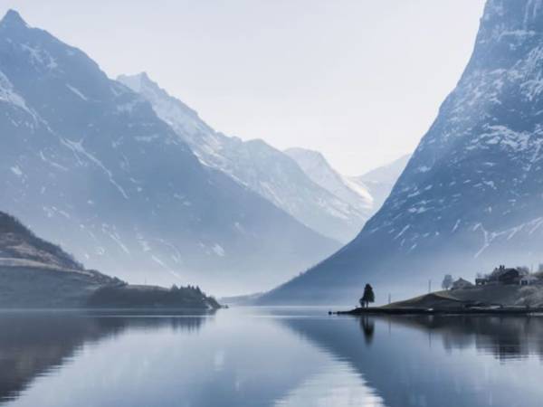
0
On this tour, you will be treated to breathtaking views, local history and fascinating stories. Experience unique sights, hidden gems and natural contrasts, while listening to stories about the people and places that make the route memorable. Enjoy the journey and the impressions! Press “DOWNLOAD” and then “START” to begin the tour. You can listen to the audio guide now while you are there, or download it to listen later – anywhere.

Looking towards land, we now see Molja Lighthouse, guiding sailors safely home since 1858. Remarkably, this area contains some of the few buildings that escaped the devastating flames of Ålesund’s great fire of 1904, when almost the entire town was reduced to ashes. Here you'll find the Fisheries Museum, located in authentic maritime warehouses dating from the mid-1800s. The museum provides fascinating insights into Ålesund’s proud maritime heritage and the vital role fishing has played in the city’s history. Close by is Teaterfabrikken, a vibrant cultural venue housed in rustic, original premises, famous for its informal atmosphere and lively performances. Originally built as a factory in the 19th century, the building tells the story of Ålesund’s industrial past, long before Art Nouveau became the city’s hallmark. Together, these locations form an authentic time capsule, offering a glimpse into old Ålesund and standing as living reminders of how the city appeared before the catastrophe shaped its unique urban landscape of today.

Benvenuti a Geiranger! A volte le parole non bastano e Geiranger non può essere descritta, deve essere vissuta! Il piccolo villaggio sul fiordo circondato da montagne scoscese, fiumi danzanti e maestose cascate supera la maggior parte delle avventure Disney. E non siamo i soli a pensarlo. Pochi posti al mondo appaiono su tante liste dei luoghi più belli del mondo come Geiranger. I primi abitanti misero radici qui fin dall'età della pietra, e oggi un paio di centinaia di residenti permanenti ricevono quasi un milione di turisti ogni anno durante alcuni frenetici mesi estivi. Qui puoi passeggiare nel piccolo centro del fiordo costituito da rimesse per barche e vecchie case di legno, prendere un caffè, un gelato o assaggiare il cioccolato e la birra locali. Sentiti libero di continuare lungo la valle, lungo il fiume spumeggiante fino al Norsk fjordsenter e al leggendario Hotel Union. E una volta che inizi, le grandi esperienze naturalistiche storico-culturali si susseguono una dietro all’altra, sia che tu scelga di andare con la barca, l'auto, l'autobus, la bicicletta o a piedi.

Non è difficile capire chi si lascia abbagliare dalla magnifica e bellissima natura che ci incontra qui tra i fiordi. Tuttavia, quando scende l'oscurità o quando una fitta nebbia scende come una coltre impenetrabile tra i fianchi della valle accade qualcosa. Spesso prendono vita miti e leggende su seducenti creature della foresta, troll, serpenti marini o folletti. Questo succede anche in queste zone e molte leggende hanno messo radici nell'ambiente locale e sono ancora storie entusiasmanti sia per i bambini che per i turisti. A Valldal, in fondo al fiordo, si racconta una leggenda del tempo in cui Olav il Santo remò in questi fiordi e incontrò un enorme serpente marino. Fu una vera lotta, ma dopo un duro combattimento, Olav prese il verme e lo lanciò sulla parete rocciosa con tale forza che il verme ci rimase incastonato e possiamo vederne il segno ancora oggi. Attraverso le ingiurie del tempo, i ripidi fianchi solcati della montagna sono stati incisi con le più strane formazioni che alimentano la vivida immaginazione delle persone. Proprio qui dove stiamo passando ora, i troll possono essere visti nella parete rocciosa anche in pieno giorno. Prova! Ciò che si vede di notte, non osiamo dirlo qui.

Can you smell it? The fresh, salty sea air mixed with the scent of fish? In Ålesund, we like to say that this is the smell of money, and with good reason: The entire history and wealth of the city is built on the fish from the sea. Now we pass Aspøya and Skarbøvika, both outer districts of Ålesund, where several of Norway's largest exporters of seafood are located. From these quays, large quantities of fish are shipped out into the world every day, everything from fresh salmon – one of Norway's most important exports – to traditional whitefish such as cod and saithe. But perhaps best known of all is herring, the "silver of the sea", which historically made Ålesund one of the country's richest cities. As early as the early 20th century, fishermen flocked here to hunt for huge shoals of herring, and the city quickly became a center for herring fishing and export. Today, modern fish factories continue this legacy, with advanced technology that ensures that the fish is delivered fresh and of top quality to customers all over the world. When you smell the sea and fish, you also smell the scent of Ålesund's history, culture and prosperity.

Pochi possono tentarti con una natura così bella e incontaminata come quella che vedi qui. Il Geirangerfjord è nella prestigiosa lista UNESCO dei siti del patrimonio culturale e naturale mondiale. Qui troverai anche alcuni dei punti panoramici più spettacolari della Norvegia, indipendentemente dal mezzo di trasporto con cui arrivi al villaggio. Dal centro è possibile seguire la strada che risale la valle fino a due punti panoramici, Flydalsjuvet e Geiranger Skywalk, Dalsnibba. Flydalsjuvet si trova al centro della valle ed è attrezzato a regola d’arte con un plateau di vetro, cannocchiali panoramici e panchine, per enfatizzare lo sfondo pittoresco, il fiordo di Geiranger, dove le barche da crociera sembrano piccole barche giocattolo sullo sfondo. Qui puoi anche guardare giù per più di 100 metri nel ruggente fiume Maråkelva mentre scende lungo la valle fino al centro di Geiranger. E in cima troverai il magico Geiranger Skywalk a Dalsnibba, a 1.500 metri sul livello del mare. Lì avrai la vista sul fiordo più alta, più bella e migliore d'Europa. La passerella è costruita oltre il bordo della montagna e con una caduta libera di circa 500 metri, si ha la sensazione di galleggiare, anche se ovviamente ci si trova in completa sicurezza su una struttura solida. Tutti i punti panoramici fanno parte della Strada Turistica Nazionale, che mira a rafforzare la Norvegia come destinazione turistica.

Vedi la strada che danza su per il ripido fianco della montagna? È La strada dell’aquila, oggi segnata come strada turistica nazionale, che porta gli automobilisti attraverso 11 stretti tornanti a 620 metri sul livello del mare e fino al piccolo villaggio di fiordo di Eidsdal. La strada è stata aperta per la prima volta nel 1955 e ha dato a Geiranger un collegamento stradale per tutto l'anno, del quale avevano sofferto terribilmente la mancanza, e prese questo nome perché attraversava un'area con molte aquile. Allora come oggi, l'aquila plana maestosa lassù con la sua enorme apertura alare e scruta noi turisti quaggiù. Gli automobilisti si fecero affascinare dalla splendida vista che si rivelò dall'alto della strada fin dal suo primo giorno. Ben presto arrivarono viaggiatori da tutta la Norvegia che si fermavano lungo i tornanti per godersi la vista spettacolare, prima che l'Europa e il resto del mondo facessero il loro ingresso con moto, auto, camper e bus. Le autorità hanno progressivamente reso le condizioni più adatte ai turisti, anche per motivi di sicurezza del traffico, regolamentando e realizzando il tornante superiore, che venne chiamato Il tornante dell’aquila e divenne forse il belvedere più famoso della Norvegia. Oggi i turisti possono camminare su una piattaforma di vetro, dove possono vedere sotto di loro il fiordo, patrimonio dell’umanità, e allo stesso tempo godere di una vista panoramica su Geiranger o sulle cascate delle Sette Sorelle. E forse vedono anche il troll nella parete rocciosa dalla parte opposta. Riesci a vederlo?

On April 9, 1940, the alarm went off in Norway, and five long years of war followed. Now we pass Tueneset Coastal Fort, an important part of the extensive defenses that the occupying forces built around Ålesund. The harbor here was strategically very important, and served as one of Germany's largest convoy ports along the Norwegian coast. To protect the ships from Allied attacks, gun emplacements, bunkers and observation posts were built. The fort was to withstand any attacks from the sea and ensure safe traffic into Ålesund harbor. Today, Tueneset Coastal Fort stands as a strong historical monument from World War II. Volunteer forces have transformed the area into a museum and open-air recreation area where you can explore bunkers, gun emplacements and other traces of the war, while enjoying the beautiful view of the sea. Here you can walk around and get a unique insight into local history, while the area invites you to reflect on a dramatic period in Norway's past. On the other side of the fjord we see Godøya, which belongs to the neighboring municipality of Giske. The island is known for its beautiful nature, nice beaches and popular hiking areas with fantastic views of the Sunnmøre coast.

Ora superiamo Matvika (baia del cibo) e, come suggerisce il nome, è un punto particolarmente fertile qui nel fiordo. Qui hanno abitato persone fino al 1961, cibandosi di ciò che la terra dava loro. La posizione era particolarmente favorevole alla frutticoltura e si raccoglievano grandi quantità di mele, pere e prugne. Si coltivavano anche prodotti esotici come pomodori e albicocche, ma erano tuttavia le capre la fonte di reddito più importante. La fattoria aveva centinaia di capre che correvano e saltavano sui fianchi della montagna fino alla malga, che era mille metri più in alto. Lì le capre venivano munte a regola d'arte e gli intraprendenti allevatori producevano formaggi sia di color bianco che più scuro (il famoso brunøst). Durante il periodo invernale c’era poco cibo per gli animali lungo il fiordo, e gli intraprendenti agricoltori quindi costruirono la loro zip-line di 1.200 metri per il trasporto del fieno. Per fare un confronto, si può dire che la Zip-Line oggi più lunga della regione nordica a Flåm è di 1381 metri. Secondo quanto riferito, la Zip-line di Matvika fu costruita da ben 70 uomini da tutta la zona. Non si sa quante persone si siano lasciate scivolare giù con quella, ma in tal caso sarebbe stata probabilmente una bella esperienza.

We are now at the far end of the Borgundfjord, which takes you past the island and the district of Hessa. Closest to land you will see the popular Atlanterhavsparken, one of Northern Europe's largest and most unique saltwater aquariums. Here you can experience feeding in impressive saltwater tanks, meet penguins and seals, and explore a rich diversity of fish and sea creatures. Every Midsummer's Eve, the famous Slinningsbålet bonfire is lit at the very end of the island, and was once voted the world's tallest bonfire, and this spectacular event gathers thousands of spectators both on land and in small boats on the fjord. The Borgundfjord continues past along the center of Ålesund and inland towards the districts of Hatlane, Moa and Spjelkavik. The fjord is perhaps best known for the traditional Borgundfjordfisket, which takes place every year in February and March. Hundreds of fishing boats gather there for the big winter cod fishing - an event with deep historical roots, crucial to the local economy and culture. It is said that people could once walk across the fjord in dry shoes on all the boats from Ålesund to Langevåg on the opposite side. Langevåg is also home to the famous textile factory Devold, which has been producing quality woolen clothing for over 170 years. The Devold factory is not only a gem of industrial history, but also a popular destination where visitors can shop for quality products and experience the brand's exciting history.

Her ved inngangen til Storfjorden, Sulafjorden, ser vi nå Kvitneset forsvarsverk, strategisk plassert mellom Hareidlandet mot sør og øya Sula mot nord, med Ålesund i bakgrunnen. Dette var et omfattende anlegg, bygget av den tyske okkupasjonsmakten under andre verdenskrig. Anlegget inkluderte hele ni kanonstillinger, nitten brakker, fire bunkere og en rekke andre militære installasjoner. Kvitneset var en del av det som ble kalt Festung Norwegen – Tysklands store befestningsprogram langs norskekysten. Sammen med tusenvis av lignende anlegg fra Nordkapp i nord til Biscayabukta i sør, inngikk det i The Atlantic Wall, en enorm forsvarslinje mot en fryktet alliert invasjon. Herfra kunne tyskerne kontrollere innseilingen mot Ålesund og overvåke skipstrafikken langs kysten, en livsnerve for forsyninger og troppeforflytninger. I dag ligger ruinene som stille vitnesbyrd om en dramatisk periode i Europas historie. Området er populært for turer, med flott utsikt over havet og innseilingen mot Sunnmøre. Samtidig gir stedet en sterk påminnelse om krigens nærvær, og det selv i det vakreste omgivelser.

C'era una volta una strega fidanzata con un bell'uomo, che la lasciò per una governante di Geiranger. Egli le fece la proposta e presto sia lui che la sposa con l'intero corteo nuziale al seguito entrarono nel fiordo verso la chiesa di Stranda. La strega era particolarmente scontenta di questo e quando vide partire la festa nuziale, riempì una ciotola d'acqua nella sua cucina. Fece roteare la ciotola in tondo mentre respirava e ansimava freneticamente. Sul fiordo, il vento si alzò e le onde crebbero e quando la strega rovesciò la ciotola, anche tutte le barche della festa nuziale si capovolsero e affondarono tutti. Questa leggenda può essere letta nel libro del villaggio locale e si sostiene che il parroco abbia remato nel fiordo e abbia dipinto una croce bianca sulla parete in fondo al fiordo che stiamo attraversando ora. Ecco perché questo posto ha anche preso il nome Korsen (croce). In Norvegia sono circa 300 le persone confermate condannate a morte per stregoneria, ma la strega da cui ha origine questa storia non è una di loro. Nel link allegato è possibile leggere la sentenza del 1614 contro Anna Andersdatter di Hellebostad, che ricevette una condanna molto più mite.

Cosa hanno in comune Il corteggiatore, Le sette sorelle e Le braci dell’Inferno? Sono tutte attrazioni turistiche del Geirangerfjord. Inoltre, sono tre gustose birre nell'assortimento del Birrificio Geiranger. Questo villaggio turistico ha una lunga tradizione di produzione della birra. Tutte le fattorie avevano per lo più birra propria, che veniva prodotta per Natale, ma si creava spesso una disputa su chi producesse la birra migliore. Presso l'Hotel Union veniva quindi organizzato uno speciale concorso durante le feste dove gli sfortunati dal buon palato dovevano assaggiare le birre in gara fino a determinarne la migliore birra dell'anno. Il vincitore prendeva il titolo di Re della birra di Geiranger, un titolo altrettanto importante che quello assegnato ad altri campioni in altri importanti rami. Il birrificio di Geiranger ha portato avanti queste tradizioni e produce nuovi entusiasmanti tipi di birra che sono disponibili in negozi, punti vendita e ristoranti in tutto il Paese.

Coloro che in passato vivevano nelle fattorie di montagna lungo il fiordo non soffrivano certo di vertigini. Ora superiamo la fattoria di montagna Skageflå, che è stata abbandonata 100 anni fa. Si trova in posizione idilliaca su un soleggiato altopiano di montagna a 250 metri sul fianco ripido della montagna. Skageflå è una delle dieci fattorie di montagna del Geirangerfjord che sono stati trasferiti. La posizione spettacolare e l'arioso e ripido sentiero in salita, fanno di questo maso il più famoso tra esse. Come probabilmente puoi capire, non era del tutto privo di periocoli né arrivare alla fattoria né viverci. Il sentiero che oggi sale a Skageflå è tuttavia sicuro. È stato migliorato e messo in sicurezza gradualmente negli ultimi 150 anni. In passato, i resistenti abitanti dei fiordi dovettero imparare a convivere con i molti insidiosi pericoli che si nascondono lassù. I bambini andavano a scuola a Geiranger in cicli di un paio di settimane, e dovevano sia studiare che partecipare agli impegnativi lavori agricoli quando erano a casa. I bambini più piccoli venivano assicurati con delle corde in modo che non si precipitassero dal pericoloso pendio della montagna. Oggi i masi sono utilizzati come case vacanza o mete turistiche, ma sono quindi sconsigliati a chi soffre di vertigini.

You probably see one or two ferries on the fjord right now. The ferry route Solavågen - Festøy connects Ålesund and Ørsta/Volda with several ferries in traffic at any time. Today, people are particularly dependent on car ferries in Western and Northern Norway, where fjords cut deep into the landscape and make it impossible – or at least difficult – to get up or down the coast. Especially in Western Norway, with its many long fjord arms, travelers depend on ferries to get around. In this fjord alone, there are at least 6 ferry routes if we include the fjord arms. A ferry trip can be an experience in itself on the idyllic fjords of Sunnmøre. We have about 130 ferry connections in Norway and ferries are an important part of the Norwegian transport system. 20 million vehicles and 40 million passengers are transported on Norwegian car ferries annually.

Forse ti stai chiedendo, perché le persone si sono stabilite in questi luoghi impervi? Sembra un po' strano, ma in Norvegia c'era effettivamente scarsità di spazio a partire dal 1500. In quel periodo, Geiranger era talmente popolata che le persone non riuscivano a trovare case o terreni. La soluzione fu quella di trasferirsi in un luogo dove potessero essere autosufficienti, spesso con i propri familiari più stretti. Per questo motivo, spesso vediamo insediamenti lungo la maggior parte dei polmoni verdi del fiordo e fattorie lungo i lati della valle. L'alternativa era spostarsi verso l'interno o verso la costa. Nell'entroterra non c'era molta possibilità di pescare e lungo la costa non c'erano molte opportunità di caccia, ma qui nei fiordi c'erano entrambe le cose. La vita lungo il fiordo e sui fianchi della valle offriva ovviamente delle sfide, ma aveva anche molti punti di forza. Ogni Natale il fiordo buio era pieno di barche a remi dirette a Geiranger con le lanterne sulle rispettive poppe. Doveva trattarsi di uno spettacolo meraviglioso e solenne. In queste fattorie gli abitanti hanno vissuto a stretto contatto con la natura per molte generazioni, ma a poco a poco la vita è diventata troppo dura e dall'inizio del 1900 è iniziata l'emigrazione. Oggi, la maggior parte delle fattorie sono utilizzate come case per il fine settimana o vengono affittate ai turisti.

Tra poco vedrai una gola che si apre nel ripido fianco della montagna, a circa 1.200 metri di altezza. Si dice che sia stato il Diavolo stesso a crearla, e quindi ha preso il nome di colonna del Diavolo (Djevlegjølet o Helvetesgjølet). La leggenda dice che il Diavolo sedeva in cima alla montagna e guardava le stelle, ma poi si addormentò e quando sorse il sole ebbe così fretta di tornare a casa, che si portò via gran parte del fianco della montagna. Sul lato opposto del fiordo si trova la fattoria Syltavika, proprio in fondo al fiordo, e se si guarda a 400 metri sopra di esso, si vede la fattoria di montagna Blomberg. Entrambe le fattorie, e molte altre in questi fiordi, sono state restaurate e curate dall'associazione di volontariato Amici di Storfjord. Il loro lavoro è indispensabile e aiuta a salvaguardare sia la storia che le piacevoli attrazioni per le generazioni attuali e future.

We are now sailing along Hareidlandet and passing Hareid. It is a lively small town that functions as an important commercial center on the southern side of Sunnmøre. Just a ten-minute drive away is Ulsteinvik, known as the heart of one of the world's most innovative shipbuilding industries. Here you will find, among others, Kleven Verft and Ulstein Group, both with a rich history and internationally recognized for their groundbreaking ship designs and advanced offshore vessels. Hareidlandet is one of the largest islands in Norway and rich in sporting achievements. In Ulsteinvik you will find the football club Hødd, which has been at the top of Norwegian football for decades, and won the Norwegian Championship in 2012, among other things. Ulsteinvik is also the hometown of world star Karsten Warholm, Olympic champion and world record holder in the 400 meter hurdles. Åge Hareide, known as both a national team coach and former top player in Norwegian and international football, also comes from Hareid. Together, Hareid and Ulsteinvik form an area characterized by both industrial strength and strong sports traditions – all surrounded by magnificent nature and beautiful fjord landscapes that reflect the rich history and future-oriented driving force of Sunnmøre.

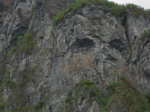
Hai mai sentito parlare del corteggiatore che posò il suo sguardo su sette selvagge sorelle non sposate, ma ognuna di loro lo rifiutò? Molti credono che il corteggiatore divenne così depresso da lasciarsi andare alla bottiglia, per poi cercare rifugio nella cascata sul fianco della montagna, che stiamo passando ora. Pertanto, la cascata ha anche la caratteristica forma a bottiglia secondo le leggende locali. Sul lato opposto del fiordo, vedi uno dei motivi fotografici più famosi della Norvegia, vale a dire le sette caratteristiche cascate dal nome "le sette sorelle". Da lontano possono assomigliare ai capelli di sette donne, da cui il nome "le 7 sorelle". Le cascate sono uno spettacolo impressionante, soprattutto perché lo scioglimento della neve è abbondante e fornisce un solido nutrimento per le cascate, che in media sono in caduta libera per ben 250 metri. 
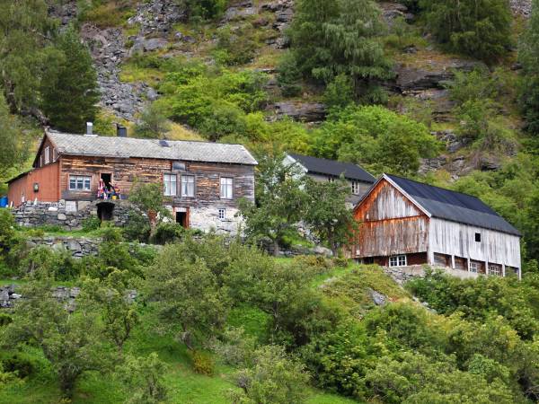
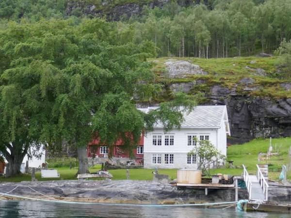
E che tu ci creda o no, su un piccolo altopiano di montagna, quasi in cima alle sette sorelle, si trova la fattoria Knivsflå, che fu abbandonata per il rischio di frane. È oggi una destinazione turistica molto popolare, con viste fantastiche e spettacolari sul fiordo di Geiranger, mentre allo stesso tempo si può conoscere la storia unica dei tempi in cui la gente viveva ancora lì.

Right here, in the waters we are now sailing through, one of the largest and most famous Viking battles in Norwegian history took place. We pass Hjørungavåg to the west, the place that has given its name to the Battle of Hjørungavåg, a dramatic battle that, according to the sagas, took place around the year 986. The battle was between the powerful Earl of Ladejarl Eirik and an invading Danish army supported by the feared Jomsvikings – legendary mercenaries from the Baltic region. According to the sagas, the battle was intense and bloody, marked by harsh weather and rough seas. Against all odds, the Norwegian forces managed to win a crushing victory, an event that consolidated Norway’s independence and strengthened the Earl’s power along the coast. Although historians still debate the details of the battle, its memories live on in local pride and culture. Today, you will find monuments and annual commemorations in Hjørungavåg that honor this important event. Now, as you look towards land, you can imagine the huge warships and hear the echoes of shields clashing in battle on the foaming waves.

Sei pronto per un'avventura? I fiordi norvegesi sono un punto di partenza perfetto per attività che fanno battere il cuore più forte del solito. Ce ne sono per tutti i gusti, indipendentemente dalla forma fisica. Se ti piace camminare, sia i piccoli villaggi che le alte vette offrono escursioni che non dimenticherai facilmente. Forse il fiordo ti tenta con una breve gita in paddleboard o sfrecciando sulle onde su un motoscafo. Molte delle stradine nel fiordo sono piste ciclabili ben tenute e piacevoli, mentre i fianchi della valle sono eccellenti per la mountain bike. Forse ti tenta provare ad arrampicarti lungo il fiume di Geiranger, in equilibrio sui ponti nepalesi o sorvolando gole e cascate. E se ciò non bastasse, c'è la possibilità di fare escursioni sia in acqua, che a terra e in montagna. Dopo esperienze così intense, può essere utile scaricare l’adrenalina e sudare, e cosa c'è di meglio di un piccolo bagno nel fiordo prima di sistemarsi in uno dei tanti alloggi accoglienti della zona. Le possibilità sono molte. Controlla i link per alcune di queste attrazioni.

Per circa due settimane all'anno si verifica un fenomeno molto particolare, che stiamo per osservare ora. L'acqua di disgelo dell'alto Monte Sunnmør raggiunge il suo culmine proprio qui, quando l'acqua si precipita giù dalla montagna e crea quello che è noto come il velo della sposa. L'omonima cascata produce poi uno spruzzo delizioso e sottile che, insieme al vento, stende l'acqua sulla strada di montagna come un velo da sposa trasparente e bello. Quando il sole splende, si crea un effetto arcobaleno incredibilmente bello che fa scattare le macchine fotografiche dei turisti vigorosamente. Ci sono ben altri sette posti in Norvegia dove una cascata è stata chiamata Brudesløret, ma questa è la più famosa e classificata tra le 50 cascate più grandi della Norvegia. Appena sopra e accanto alla famosa cascata, i masi di montagna Megardsplassen e Horvadrag sono sospesi su due stretti rilievi montuosi a quasi 500 metri sul livello del mare. L’ultimo abitante lasciò la fattoria nel 1900. Già l'anno successivo la famiglia prese in considerazione l'idea di tornare indietro, ma a quel punto una valanga di neve aveva preso tutte le case e le aveva trascinate nel fiordo. Se fossero vissuti lì, probabilmente avrebbero seguito le case fino in fondo al fiordo.

The fjord that flows inland to the east is the Vartdalsfjorden, a side arm of the mighty Sulafjorden. The narrow fjord cuts deep between steep mountains and creates a dramatic and beautiful natural arena that is typical of Sunnmøre. On the north side lies the village of Vartdal, a small community with strong traditions in fishing and agriculture. Vartdal is also known for its industrial history, including fish processing and later the plastics industry. Further inland we meet Ørsta, a powerhouse for the region with both trade, industry and an active outdoor life. Here the Sunnmøre Alps loom in the background, a paradise for mountaineers and ski enthusiasts. Even further east lies Volda, known as an important educational city with its university, strong media environment and rich cultural offerings. The city is also known for its annual documentary film festival, which attracts filmmakers from all over the world. The Vartdalsfjord connects these vibrant small communities, all with deep roots in the fjord, the mountains and the sea. When you look inland, you follow a thoroughfare that has been the lifeblood of people and trade in Sunnmøre for centuries.

La regina Sonja di Norvegia è da molti anni patrona dell' Associazione per il Turismo norvegese. È conosciuta come la regina dell'escursionismo e non c'è quasi una cima di montagna in Norvegia che lei non abbia visitato. Il Geirangerfjord, i villaggi e le montagne circostanti sono sempre stati tra le mete più visitate della regina e della sua famiglia. Nel 1993, la regina e il re hanno persino celebrato le loro nozze d'argento qui nel Geirangerfjord, al maso Skagaflå, con ospiti V.I.P. e membri reali provenienti da tutto il mondo. Gli ospiti, tra cui 7 regine, hanno anche fatto l’escursione attraverso la bellissima Norangsdalen, che ora è anche soprannominata Dronningruta (Il percorso della regina). A Geiranger, la regina, da sempre interessata all'arte e alla natura, inaugurò l'installazione di design "Fjordsetet" (poltrona sul fiordo) nel 2003 durante uno dei suoi altri viaggi nella zona. A Oslo, nel 2017 è stata inaugurata una scultura raffigurante la regina Sonja dal titolo "La regina delle escursioni".

The beautiful, idyllic fjord you see stretching into the landscape is the Hjørundfjord, one of Norway's most spectacular fjords. Surrounded by the mighty Sunnmøre Alps, with peaks rising vertically from the water's edge, this is an area that takes the breath away from most people. The Hjørundfjord winds 35 kilometers inland between majestic mountains, with small villages and farms clinging to the steep slopes. Further into the fjord you will find the charming village of Øye, where the historic Hotel Union Øye has welcomed adventurers and royalty since 1891. From Øye, the beautiful Norangsdalen, known as "Norway's narrowest valley", leads you on towards Hellesylt. From there you can take a boat into the famous Geirangerfjord, which is a UNESCO World Heritage Site. The Hjørundfjord is a paradise for nature lovers, with countless opportunities for mountain hikes, kayaking and authentic experiences close to nature. When you look inland here, you don't just see a fjord – you see one of Norway's most beautiful secrets.

To the east we see the Sykkylvsfjorden, which is a side arm of the mighty Storfjorden. Here we find Sykkylven, which is also known as Norway's furniture capital. Once there were 30 active furniture factories here with only 3,000 permanent residents. Today there are a few more, and Sykkylven has developed into a modern town, but the furniture industry still characterizes both identity and business. Among the best-known manufacturers are Ekornes, Hjellegjerde and Brunstad. Ekornes, with headquarters in Sykkylven, is particularly known for the brands Stressless and Svane. At a time when many have moved production to low-cost countries, Ekornes has kept parts of its production local - and thus continues a strong craft tradition. The furniture village has also left its mark internationally. In 2009, Sykkylven set a world record with the world's longest sofa, a full 890.25 meters long – built by the local furniture industry and set up as a spectacular symbol of the village's expertise and pride. Further along the fjord we pass Straumgjerde and the road that leads over Strandafjellet, towards Stranda and on to Hellesylt – the gateway to the Geirangerfjord.

The tourist village has a long tradition of beer brewing. All the farms had their own beer that was brewed for Christmas, often leading to a dispute over who had brewed the best beer. Therefore, a particularly serious competition was arranged at the Hotel Union where impartial people with a good palette for beer judged the beer of the year. The winner was crowned ‘Beer King of Geiranger’ a title up there with other prominent awards.

Up on the mountainside to the west you can now see Ytste Skotet, one of the most impressive and well-preserved shelf farms in Norway. The farm clings to the steep mountainside high above the Storfjord, without a road or modern conveniences. This was one of many so-called shelf farms – small farms that were located on narrow mountain shelves, often inaccessible and demanding to get to. Life here was hard, but also full of knowledge and adaptation. The farmers cultivated the land on steep slopes, kept livestock, and fetched firewood and water with raw muscle power. Transport was on foot or by boat – often with heavy loads over long distances. In winter, the farms could be completely isolated for weeks. Ytste Skotet was vacated in 1954, but is now restored and operated as a living museum. Here visitors can experience what life was like in earlier times – without electricity, machines or modern aids. All work is done by hand and with traditional tools. When you see the farm from the fjord, it is easy to be impressed by the courage, endurance and ability to survive in the steep and beautiful fjord landscape.

Here, between high mountains and deep fjords, you will find some areas with fairly flat land – rare and valuable pockets in the otherwise dramatic landscape. It was precisely in such places that farms grew up, and over time some developed into small towns. We are now passing Stordal, a good example of this. Stordal is located at the very end of the Storfjord and has long been a natural meeting point and trading place in the region. The area has a rich agricultural history, and the village is known for both its beautiful cultural landscape and strong craft traditions. In recent times, Stordal has also become known for furniture production, and the traditional craft lives on in modern forms. A distinctive feature of the village is Rosekyrkja – Stordal’s old church from 1789 – which is beautifully decorated with rose painting and historical motifs. The church is today a museum and symbolizes the village’s pride and history.

The boat now passes the Norddalsfjorden surrounded by lush valleys and postcard-perfect villages. Further into the fjord lie Eidsdal and Valldal, stops along the spectacular tourist route "The Golden Route", which connects Geiranger with Trollstigen and Åndalsnes. Valldal is known for its sweet strawberries and lush landscapes, while Fjørå has become a favorite destination for mountain bikers from all over the world. At the very end of the fjord we find Tafjord – a peaceful place with dramatic memories. On the night of April 7, 1934, large parts of the mountain Langhamaren collapsed into the fjord. The collapse triggered an enormous tidal wave that washed over the village. At its highest, the wave was almost 64 meters, and the destruction was catastrophic. As many as 40 people lost their lives, houses and farms were demolished, and the landscape was changed forever. The contrast between today's quiet nature and the violent event makes a strong impression. Here in Norddalsfjorden, people live close to the beauty of nature – and the reminder of its unpredictable powers. This is a landscape that both gives and takes, and that is never forgotten.

We are now approaching Stranda, a town beautifully situated between fjord and mountains, and known far beyond Sunnmøre for both food and nature. This is the home of Grandiosa – Norway’s best-selling frozen pizza – which is produced here in the Orkla factory. In addition to the pizza, Stranda is also known for the traditional cured meat Strandamør, a delicacy based on old recipes and smoking with juniper and mountain air. But Stranda is about more than food. Right behind the town rises Strandafjellet, a popular ski center that offers some of Norway’s best opportunities for summit tours and freeriding, with panoramic views of fjords and alpine peaks. The mountain is also a favorite destination for summer trips, with the gondola taking you high up in the landscape in a short time. Stranda is a good example of how tradition, industry and nature experiences meet. Here, people live close to the elements, with the fjord as a thoroughfare and the mountain as a playground. When you look inward now, you see a village that combines food enjoyment, outdoor activities and strong local roots – and that has managed to put both itself and its pizza on the Norwegian map.

Up on the mountainside to the west, you can now see Åkernesremna – one of Norway’s most feared natural hazards. This enormous mountain range is in slow but steady motion, and when – or if – it collapses into the fjord, it could trigger a catastrophic tsunami. The masses that could collapse are estimated to be 15 to 30 times larger than the landslide that caused the Tafjord disaster in 1934, in which 40 people lost their lives. Åkernesremna is several hundred meters long and up to 60 meters deep. The mountain masses subside several centimeters every year, and geologists monitor the area closely with advanced measuring equipment and alarm systems. If the landslide is detected in time, the population in the exposed areas can be evacuated before the wave hits. This dramatic natural hazard was the inspiration for the 2015 film The Wave, which shows how a landslide from Åkerneset can send a devastating tsunami towards Geiranger. The film is based on realistic scenarios and reflects how fragile the balance between idyll and disaster is in this powerful landscape. When you look up at the mountain now, you can almost feel the tension that rests over the area – a silent reminder of the unstoppable power of nature.

We are now rounding Røneset, a small headland where mountains meet fjords, and where a special farm has captured the attention of all of Norway. Out here, without a road and isolated from the beaten track, lies the farm of the same name that became known from the NRK series No One Thought Anyone Could Live. The farm owner's simple lifestyle and love of nature touched many viewers, and the response was so great that he later got his own TV series. The farm at Røneset is an example of the many small farms we pass on this journey – farms where people have lived close to nature, in a life that required endurance, courage and sobriety. Here the fjord was the way of life and the mountains were the neighbor, and everything needed to survive had to be collected from nature or transported by boat. When you see the modest fjord farm lying there under the steep slopes, you can understand why such places both fascinate and impress. They tell a story about humanity's ability to find living space in the most unlikely places – and about a form of life that is rare today, but still inspires respect and admiration.

When you look around here – with mighty mountains, deep fjords and endless nature – you might think that there has always been plenty of space and opportunities. Yet it was precisely from here, from the Sunnmøre and Ålesund area, that many chose to leave everything and start a new life in America. Emigration really picked up after 1860. Small farms, a large increase in population, poverty, religion and hopelessness caused thousands to leave. Many from the coastal villages struggled to feed their families, and the lure of the "promised land" in the west became too strong. Between 1865 and 1915, over 800,000 Norwegians travelled to America – a significant proportion of the population. Many Sunnmøre people also set off across the sea, often from Ålesund on the first steamships. Most settled in the Midwest – Minnesota, Wisconsin and Iowa – where the climate and nature were reminiscent of Norway. They brought with them knowledge of fishing, agriculture and crafts, and built strong local communities. Today, there are countless descendants of Sunnmøring in the United States. The story of the emigration is a reminder of both hardship and hope – and of how far people were willing to go for a better life.

We are now following in the footsteps of Olav the Saint – Norway’s eternal king and a central figure in the Christianization of the country. In the year 1028, just two years before he was killed in the Battle of Stiklestad, Olav Haraldsson sailed into the Storfjord where we are now, on his way to bring Christianity to the fjord villages of Sunnmøre. We can find traces of him in several places, especially in Vegsund. Here is Olavskilden – what was once the most famous Olav tradition in outer Sunnmøre. A little up the hill from the sea we find the spring where Olav, according to tradition, drank and washed during his stay in the area. The water here was seen as holy and healing, a clear sign of the advance of Christianity. In Valldal, the legend of the “Serpent in the Mountain” also lives – a monster that, according to legend, was petrified after Olav’s blessing, as a symbolic victory over old pagan forces. Two years after this journey, in 1030, Olav fell at Stiklestad. When his grave was opened shortly afterwards, angels were said to have sung, and his hair and nails had grown. He was quickly declared a saint – and his name lives on in sagas, landscapes and beliefs.