
0
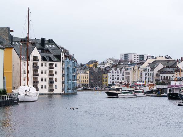
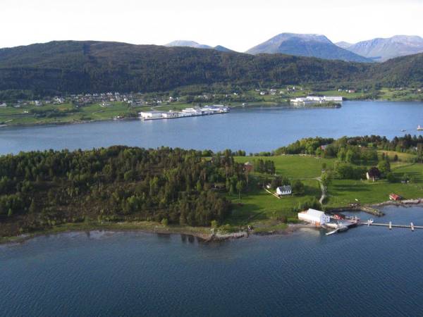
Archipelago Cruise with MS Bruvik Join us on a leisurely 2-hour cruise from Ålesund. Enjoy panoramic views of the city, the island and the fjords around Ålesund. Preferably with something good in your glass. Experience the beautiful coast around Ålesund on a relaxing archipelago cruise with Cruise Service AS. Enjoy the views of islets, skerries and historic lighthouses as you glide quietly through the crystal clear waters. Perfect for both photo enthusiasts and those who just want to enjoy the tranquility of the unique Norwegian archipelago. Departure from Ålesund Cruise Port.

Welcome aboard. You are now standing in the heart of Ålesund – one of Norway’s most distinctive cities, shaped by a single dramatic event. The night of January 23, 1904, a fire broke out just a stone’s throw from here, and within a few hours, almost the entire city was reduced to ashes. More than 800 houses were lost, and around 10,000 people were left without homes. But what makes Ålesund unique is what came next. The city was rebuilt quickly, in Jugendstil, with detailed facades, towers, and spires inspired by Europe. Among those who contributed to the rebuilding was Kaiser Wilhelm II of Germany. And from the sea, it all makes the most sense. Because this is how Ålesund was first discovered. Now we leave the harbor and move out into the landscape that has always been the foundation of the city: the archipelago.

You are now moving into Brosundet – where the city truly comes together. Here, the houses stand almost out in the water, and that is no coincidence. This was the working area of Ålesund, where fish was unloaded, processed, and sent out into the world. But this is also the place where everything changed. Very close to here, the great fire of 1904 began, and in the tightly packed wooden houses, the flames quickly took hold. Through this narrow strait, the fire spread further throughout the city. What you see now is what came after. Stone, brick, and Jugendstil – built to withstand more and last longer. Notice the spires, towers, and details around you. Ålesund was not just rebuilt, it was elevated.

As you now glide out of Brosundet, the city begins to open up. You can see the southern side of the harbor – an area that for a long time has been the driving force behind Ålesund’s economy. From here, enormous quantities of dried and salted cod were exported to the world, especially to Spain and Portugal. At its peak, this was one of Norway’s most important export harbors for seafood, and much of the value creation took place right here. The buildings along the quay were part of the entire production chain, from receiving to export, and the smell of fish once defined the whole city. Today, much has changed, but the structure remains the same. The quays, the warehouses, and the close connection to the sea – these are the elements that have shaped Ålesund.

You are now moving into Steinvågsundet – one of the main routes leading out to the open sea. Here, you can feel the city beginning to loosen its grip, as the landscape opens up around you. This is still an important passage, used for generations by boats traveling in and out of Ålesund. At the same time, you can clearly see how nature begins to take over. The strait is shaped by ice, sea, and time – not by human hands. And that is exactly why the city is located here. At a natural meeting point between land and sea.

You are now traveling through Steinvågsundet – the gateway to the open sea. Everything that was sent out into the world had to pass through here. Fish, goods, and people. Notice how the landscape begins to change. The city pulls back, and it becomes more open, more exposed to the weather, and more coastal. This has always been a threshold. A point where you move from the safe to the unpredictable. For generations, people have passed through here, heading straight out into what could be both a livelihood and a danger to life.

On the right-hand side, out toward the open sea, you can see a small red lighthouse that almost looks like it stands alone in the waves. This is Molja Lighthouse – one of Norway’s most distinctive lighthouses. It was built in 1858 to guide ships safely into Ålesund, and its location is no coincidence. This is where the sea meets the city, and navigation could be challenging, especially in darkness and rough weather. Today, the lighthouse is perhaps best known for something entirely different – inside, there is actually a hotel room. Just a single room, considered one of the most unique places to stay in Norway. Just inside lies the inner harbor, much calmer and more sheltered. The contrast is clear. On the outside, you have the open sea and the forces of nature, while inside, the boats rest safely, just as they have for generations. This marks the transition between the exposed and the protected – and is a key reason why Ålesund was established right here.

Around you now, the landscape opens up into Ellingsøyfjorden – the fjord that separates Ålesund from the island of Ellingsøya to the north. This is not just an open space on the map. It is an important route that connects the city to the rest of the coast, and further inland toward places like Skodje and the Storfjord. Fast ferries, fishing vessels, and larger ships pass through here every day. The island of Ellingsøya that you see around you is actually one of the most populated islands in the area, with several thousand residents. Today, it is connected to Ålesund by tunnels beneath the fjord, but in the past, the sea route was the only connection – and this fjord was the lifeline. At the same time, this is an area that may seem calm, but it is closely tied to the weather and the sea. Open enough to feel the forces from outside, yet still part of the sheltered coastal landscape. It is this balance that has made it possible for people to live and travel here for generations.

Do you see the flat islands out on the horizon? Out there lies Giske – a place with far more history than the landscape might reveal at first glance. This was one of the most important centers of power in Norway during the Middle Ages. The Giske family was based here, one of the most powerful noble families in the country, with close ties to both the monarchy and the church. In the middle of the island, Giske Church still stands, built in stone in the 12th century – something that in itself reflects how important this place once was. If you look a little further out toward the open sea, you can spot Alnes Lighthouse on the island of Godøya. The lighthouse was built in 1876 to guide ships safely past the exposed stretch of ocean outside. This is one of the most weather-exposed areas along the Sunnmøre coast, and the lighthouse has been crucial in preventing shipwrecks. Out here, you can truly feel the transition. From historic centers of power and settlement – to the open ocean that has always lain just beyond, shaping the conditions for all life along this coast.

Right in front of you lies Godøya – an island that truly marks the transition from the sheltered archipelago to the open ocean. Out here, the landscape is more open and more exposed. There is less to shield you from the weather, and you quickly sense that this is the outer edge of the protected coastal system. On clear days, the sea may seem calm, but this is an area that can turn harsh and demanding when the weather changes. Godøya is also known for the distinctive mountain Storhornet, which rises above the island and serves as a natural landmark for both sailors and people on land. For generations, this has been a point used for navigation – long before modern technology took over. Places like this remind you of what life along the coast is really about. Not just beautiful scenery, but also respect for the sea – and the understanding that life out here has always been shaped by its forces.

Along the rocky shoreline out here lies Atlanterhavsparken – and this is no ordinary aquarium. Here you will find one of Northern Europe’s largest saltwater tanks, where large fish such as cod, saithe, and halibut swim in an environment designed to be as close to nature as possible. The water is pumped directly in from the ocean outside, so what you see inside is the same life that exists right beneath your boat right now. And yes – they have daily feeding sessions. Divers actually go down into the tank and feed the fish in front of visitors. It is quite a powerful experience to watch, especially when the largest predatory fish come close. At the same time, this is also an active center for knowledge and research on marine life. But it is perhaps this combination that makes the place special – you can both learn something and truly experience it up close. It is one of those places along the coast that is well worth a visit.

About 40 kilometers southwest of Ålesund, near an island called Runde, one of the most famous treasure stories along the Norwegian coast took place. In 1725, the Dutch ship Akerendam was wrecked just off the island. On board were large quantities of silver coins, on their way from Asia to Europe. The ship sank, and the treasure disappeared into the sea. It was not discovered again until more than 250 years later, in the 1970s, when divers made one of the largest treasure finds in Norway. Thousands of silver coins were recovered from the seabed. And even today, many believe that not everything was found. So even if all you see around you now is open sea, it is worth remembering that this coastline hides far more than what is visible on the surface.

On the left-hand side, you can see the island of Hessa, and just behind the houses along the shoreline rises Sukkertoppen – one of the most popular hiking destinations in Ålesund. It is not a large mountain, but the view from the top is something truly special. From the summit, you can look straight out toward the open ocean on one side, and back over the entire city on the other. It is the kind of place that almost every local has visited at least once. The western side of the mountain, facing the open sea, was affected by a wildfire on March 17, 2026. The fire spread quickly through the dry terrain and led to the evacuation of several homes in the area – a reminder of how quickly conditions can change out here. Hessa is much like the rest of this area. Close to the city, yet deeply connected to nature. A place where you can feel how quickly the landscape takes over – and how little truly separates the urban from the wild along this coastline.

Look to the right. There lies Sula – and the mountain rising straight up from the sea. This is one of the most important landmarks along this stretch of coastline. Before GPS and modern navigation systems, it was features like this that people relied on to find their way home. The stretch you are traveling through now is also well known among local boat operators. The sea can build quickly here when winds come in from the west. It may not seem dramatic today, but it is an area where you notice the difference immediately when the weather turns. At the same time, this is one of the main routes out to the fishing grounds. Generations of fishermen have set out from here, heading straight into the open sea. So what you are passing now is not just “open water” – it is the gateway to the workplace that built this entire region.

Do you see the buildings on the opposite side now? That is Langevåg on the island of Sula. This is not primarily a tourist destination, but a place where people actually live and work along the coast. Here you will find, among other things, the Devold factory – one of Norway’s oldest textile producers, known for wool clothing that has been used by both fishermen and explorers for more than 160 years. But Langevåg is just as much about the sea. The harbor here has long been important for both fishing and industry, and the area is still shaped by activity related to boats, shipyards, and business. This is part of the modern coastline – not just history, but something that is still very much alive. And that is perhaps what makes the contrast interesting. You have nature all around you, the open ocean just beyond – and at the same time, communities like this, built on exactly the conditions you see here.

We are now in the middle of the Borgundfjord, widely known for its rich winter cod fishing. Every year, early in the season, large numbers of cod enter the fjord to spawn – marking the start of the traditional Borgundfjord fishery. It’s said that during peak season, there’s so much cod in the water you could catch it with a bucket from the shoreline! This fishery has played an important role in Ålesund’s development and remains a vibrant part of the region’s identity. On the southern side of the fjord, we see Langevåg – a village with deep roots in both fishing and textile industry. Here lies the historic Devold Factory, founded in the 1800s, known for producing durable wool clothing for fishermen and polar explorers. Today, the old factory site has been transformed into a cultural hub with shops, a café, a museum, and an art gallery – a great example of tradition meeting modern life.

We can now see Borgund to the north – a place rich in history and one of the most fascinating archaeological sites in all of Northwestern Norway. Here you’ll find Borgund Church, a beautiful stone church from the 12th century, standing close to the site of a once-thriving medieval town: Borgundkaupangen. Have you heard of it? In the Middle Ages, Borgundkaupangen was the largest town between Bergen and Trondheim – a lively trading post with international connections and traces of both Viking culture and early Christianity. Over 45,000 archaeological finds have been uncovered here, including bridges, graves, roads, houses, and boathouses. Today, the site is part of a major research project at the University of Bergen, and you can even join archaeologists on a time-traveling journey through the town that vanished. The ancient Pilgrim’s Route to Nidaros also passed through this landscape. And according to legend, one of Saint Olav’s men was killed here during Norway’s Christianization. His blood is said to have stained a rock by the shore – and the red mark can still be seen to this day. This is also where you’ll find the Medieval Museum and Sunnmøre Museum, offering vivid insights into life along the coast from the Viking Age, through the Middle Ages, and into the present day.

Heading into Ålesund, we now see Volsdalsberga – a beautiful recreational area with smooth coastal rocks, a bathing spot, and green spaces that stretch all the way down to the fjord. On warm days, this is a popular place for swimming, picnics, and peaceful views of the sea. Just behind it stands Color Line Stadium – the home ground of Aalesunds Fotballklubb, better known as AAFK. The club has won the Norwegian Football Cup twice, in 2009 and 2011, and remains a source of local pride and identity. Along the waterfront, modern apartment buildings are rising – part of new residential areas where people live close to both the sea and city centre. It’s a great example of how Ålesund blends nature, sports, and urban life – with its eyes set firmly on the future.

Slinningsbålet is a major event held every year on Midsummer’s Eve, June 24th. The bonfire is mainly built from wooden pallets. The tradition of lighting bonfires on Midsummer goes back several hundred years, at one time it was common to see many large bonfires built around Ålesund. Over the years, one bonfire after another has disappeared from the shoreline, but stories are still told about how different groups of young builders would row around and steal materials from neighboring bonfires. This passion for building bonfires still lives on among the youth at Slinningsodden. There have been many attempts to build bigger and taller structures, and in 2016, a record attempt was made. The attempt was successful, and the Slinningsbonfire reached a height of 47.4 meters, officially recognized by Guinness World Records.

Ålesund is a modern and versatile city, known for its architecture, bustling port, and deep connection to the sea. As we approach the city centre, you’re looking at a place shaped by both catastrophe and innovation. Before the great fire of 1904, Ålesund was a thriving fishing town, with cod and clipfish as its main exports. Then came the night that changed everything – a single spark, strong winds, and by morning, nearly the entire town lay in ruins. The rebuilding became a national effort. Young architects, inspired by the Art Nouveau movement, redesigned the city using stone and brick instead of wood. The result is what you see today – towers, spires, and curved facades in a unified, elegant style. Today, Ålesund is a global hub for fishing, seafood, maritime technology, and innovation. The city exports everything from salmon to cutting-edge ship design and aquaculture systems. With top-level education and research institutions, Ålesund is now a centre for sustainable development – set in one of the most stunning coastal landscapes in the world.