
0
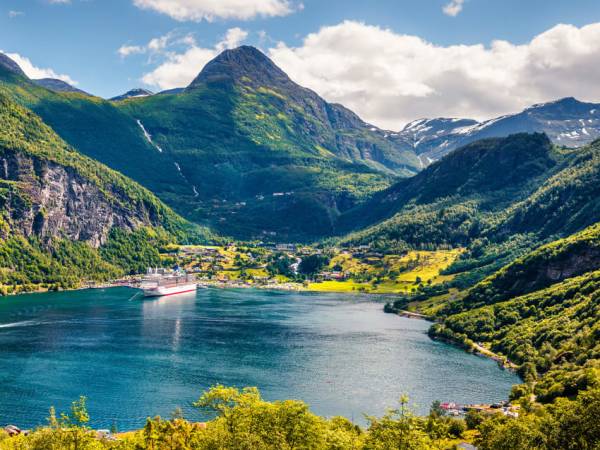
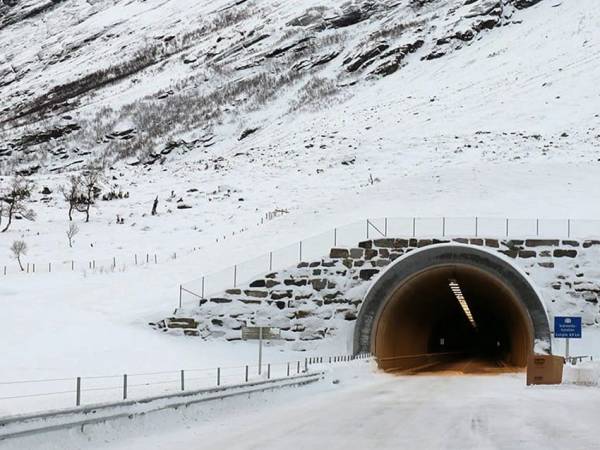
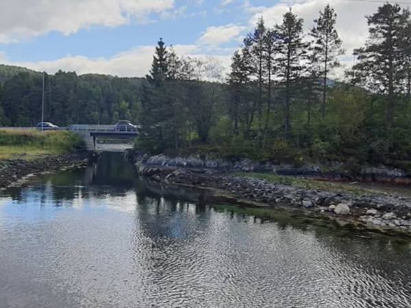
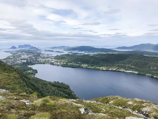
Welcome to the bus tour from Geiranger to Ålesund – a journey through some of the most spectacular landscapes Norway has to offer. After experiencing the world heritage fjord of Geirangerfjorden, the tour continues by bus through steep mountain sides, deep valleys and vibrant villages. You will pass iconic places such as Ørnesvingene, with its dramatic hairpin bends and views over the fjord, before the tour continues towards the ferry pier in Eidsdal. Here we cross the Norddalsfjorden by ferry to Linge – a classic part of the journey in Sunnmøre – before we continue along the fjord and mountains. End the day with the Kokarsteinen viewpoint before the tour returns to the Art Nouveau town of Ålesund – all in one unforgettable trip! Along the way, you will hear stories about the nature, people and life along this route – from dramatic landscapes shaped by glaciers, to small local communities with strong traditions. Sit back, enjoy the view – and let the landscape tell its story. Press "DOWNLOAD" and then "START" to open the experience. Press the language button to choose from our 14 available languages. Tickets: https://www.cruise-service.no/

Welcome to this bus journey through Sunnmøre, a region of dramatic scenery, natural beauty, and fascinating history. Around almost every bend, a new impression awaits — and by the time we arrive in Ålesund, you’ll carry with you a journey full of memories and striking experiences. The trip takes around two and a half hours, including the ferry crossing from Eidsdal to Linge. So sit back, relax, and enjoy the ride through one of the most spectacular parts of Norway.

You may be wondering what life was like here in earlier times. In Geiranger, life was demanding, dramatic, and beautiful all at once. People lived close to nature, clinging to the steep mountainsides and relying on whatever the landscape could provide. Everything was transported by boat — food, hay, livestock, and people. During winter, the village could be cut off for weeks, and families had to manage with what they already had. Still, the people here were proud, and the sense of community was strong. If you look up toward the steep mountain walls, you’ll see some of Norway’s most remarkable mountain farms. Skageflå, Knivsflå, and Blomberg were built on narrow ledges high above the fjord, where families kept cows and goats and cut hay on the steep slopes. Reaching them often meant climbing by rope and ladder, and children were sometimes tied for safety. Today, Skageflå can be reached on foot, but it is hard to imagine what it must have been like to live there year-round — through storms, snow, and long stretches of silence. These farms tell a powerful story of courage, endurance, and the ability to adapt to the forces of nature.

We’re now climbing one of Norway’s most spectacular and most photographed roads: the Eagle Road, or Ørnevegen. It winds its way up from the Geirangerfjord through eleven tight hairpin bends to the viewpoint at Eagle Bend, 620 meters above sea level. When it opened in 1955, it became the first proper road connection between Geiranger and the rest of Sunnmøre. Before that, people had to travel by boat to Eidsdal or Valldal, and many also crossed the mountains on foot. The road takes its name from the steep mountain slopes where eagles have nested and soared above the fjord for generations. At the top, one of Norway’s most famous views awaits — the Seven Sisters waterfalls and the fjord winding between towering mountains. It is a sight that leaves a lasting impression, even on experienced travelers.

Now you can see the Geirangerfjord in all its grandeur. This is perhaps Norway’s most iconic and beautiful fjord. It stretches from Geiranger to Hellesylt, and from there the sea route continues through a maze of fjords, dramatic mountains, and quiet villages, before eventually reaching the jugendstil town of Ålesund. The Geirangerfjord is listed as a UNESCO World Heritage Site and is one of Norway’s most visited destinations. Every summer, hundreds of thousands of people come here from around the world, many of them by cruise ship — and today, you are among those experiencing this remarkable place up close. The fjord before you is more than a natural wonder. It is also a symbol of Norway itself — a place where history, silence, and nature come together.

If you’re afraid of heights, this may be a moment to look away for a second. But if you want to experience one of Norway’s most famous views, this is the time to keep your eyes open. Ahead of us is Eagle Bend, the best-known viewpoint along the Eagle Road. From here, the Geirangerfjord opens wide between sheer mountain walls. To the east lies Geiranger, and to the west you can see the Seven Sisters waterfalls and the mountain farm Knivsflå, resting like a green shelf halfway up the mountainside. The landscape feels like a living postcard, with light and color constantly shifting. If you look carefully at the mountain wall across the fjord, slightly to the west, you may notice the shape of a troll’s face formed by nature itself — forehead, nose, and chin. Perhaps it is the fjord’s own guardian. Eagle Bend reminds us how small we are, and how powerful the mountain world around us truly is.

We’re now entering the Indreeide Tunnel, one of the most significant road improvements this region has seen in many years. The tunnel between Korsmyra and Indreeide officially opened in March 2024, marking the beginning of a new chapter for Geiranger. At five kilometers long, it gives the village a year-round road connection for the first time ever, replacing a stretch of road that once had as many as thirteen avalanche-prone points. In the past, the road could be closed for weeks because of snow or rockslides. Today, the connection is both safer and more dependable. For local residents, this means better access to school, work, and essential services. For travelers like you, it means a smoother and more secure journey between Geiranger and the rest of Sunnmøre.

Now you can see Eidsdalsvatnet, often simply called Eidsvatnet. It is considered one of the best trout lakes in Norway that can be reached directly from a main road, and it has been important to both locals and visitors for generations. Around the lake, you’ll find small campsites and cabins for rent, ideal for those who want to enjoy the silence, try their luck fishing, or simply spend time close to nature. Many families return here year after year to swim, paddle, or hike in the surrounding mountains. In winter, the lake lies quiet beneath a smooth cover of ice. In summer, the area fills with life, laughter, and the scent of campfires. Eidsdalsvatnet is a place where people come to slow down and reconnect with nature — a good example of how the valley has combined tradition, tourism, and the natural landscape in a balanced way.

You’ve probably noticed how green and fertile the landscape is around us, even up here in the mountains. That is something people in the fjord villages have made use of for centuries. Not far from here lies Herdalssetra, one of Norway’s largest and best-preserved summer farms. Farming there has continued without interruption for more than 300 years. Every summer, cows, goats, sheep, and horses are brought up into the mountains to graze, just as they were in the past. The farm consists of around 30 timber buildings, and several of them are still in use and can even be rented for overnight stays. If you visit, you can meet the milkmaids, taste fresh brown cheese, and see how old traditions are still kept alive. Herdalssetra is a living cultural monument — where the hard work of the past meets today’s commitment to preserving rural heritage.

The landscape now opens up as we arrive in Eidsdal, a small, charming, and lively fjord village surrounded by high mountains and green fields. From here, we’ll take the ferry across to Linge — a crossing of about 15 minutes that forms part of the classic route between Geiranger and Ålesund. Eidsdal has deep traditions in farming and summer mountain agriculture, and many families have worked the land here for generations. Today, the village is also well known for tourism, with campsites, cabins, and farms welcoming visitors from all over the world. Although Eidsdal is small, its sense of community is strong. In summer, the village is full of life as the ferry moves steadily back and forth across the fjord.

We’re now crossing the Norddalsfjord, a branch of the great Storfjord. To the west, you can see Stranda, often nicknamed the “pizza village,” known for its food industry, the ski area at Strandafjellet, and of course its friendly people. Looking inland, the fjord stretches toward the villages of Norddal, Valldal, and Fjørå, and furthest in lies Tafjord, surrounded by steep mountains and dramatic scenery. For centuries, this fjord was the lifeline of the communities along its shores. Before roads were built, all travel happened on the water. Boats carried people, animals, and goods between the villages, keeping these small communities connected. Today, the fjord is part of the scenic route between Geiranger and Ålesund, but traces of the old fjord life remain — perhaps in a fishing boat or a lone paddler on the water.

Do you like strawberries? From Linge, we now continue toward Ålesund, but if we had gone the other way, we would have reached Valldal — famous as the strawberry valley, and for many, home to some of the finest strawberries in Norway. The mild fjord climate and long summer evenings create excellent conditions for these sweet red berries. In summer, small roadside stalls sell freshly picked strawberries, juice, and jam. Further along the fjord lie the villages of Fjørå and Tafjord, both surrounded by dramatic landscapes. From Valldal, you can also head up toward Trollstigen, one of Norway’s most famous scenic roads. It winds its way up the mountainside through sharp hairpin bends, past waterfalls and viewpoints. Trollstigen is more than an engineering achievement — it is a fairytale landscape of rock, water, and old legend, where trolls are still said to watch over the road.

On the night of April 7th, 1934, huge masses of rock broke loose from the mountain Langhamaren and crashed into the fjord by Tafjord, the village lying at the innermost end of the fjord we are following now. The impact triggered a massive tsunami, reaching as high as 62 meters, it struck Tafjord and Fjørå with tremendous force. Forty people lost their lives, and many homes were swept into the sea in a matter of seconds. The disaster shocked all of Norway, but it also led to important new knowledge about mountain slides and fjord waves, as well as improved preparedness. Today, Tafjord stands as a symbol of resilience and recovery — a village that rebuilt itself and now lives closely with the forces of nature through both hydropower and research.

We’re now passing Liabygda, a beautiful fjord village where the Norddalsfjord meets the Storfjord. People here live close to nature, and many combine farming and small-scale industry with tourism and outdoor life. From the village, trails lead up toward Ansokhornet, a mountain with wonderful views over the Storfjord and the Sunnmøre Alps. On clear days, you can see all the way to Stranda and deep into the Tafjord mountains. It is exactly the kind of view that explains why this part of the country is called Fjord Norway. Down by the fjord, the ferry crosses to Stranda. It has been an important connection for decades, linking the villages together in much the same way the fjord always has.

We’ll soon cross the Stordal River, which flows down from the mountains and out into the Storfjord. The river is an important part of life here, providing nourishment, power, and habitat for wildlife and fish. On good summer days, anglers stand along the banks hoping for trout or salmon, much as people have done for generations. From this area, a road also leads toward Overøye and the mountains above Stordal. Arena Overøye is a modern ski resort with slopes, lifts, and cross-country tracks. In winter, it is a popular destination for both locals and visitors, while summer brings hiking and quiet moments in the mountains. Stordal is a place where nature remains part of everyday life all year round — for work, recreation, and enjoyment.

We’re now approaching Stordal, and soon we’ll pass the beautiful Rose Church, one of the village’s most well-known landmarks. Built in 1789, the church is especially famous for its rich rose painting and finely carved details, created by local craftsmen and artists. It is often described as a work of art in wood, reflecting a time when both faith and craftsmanship held an important place in the fjord communities. Inside, you’ll find biblical scenes and colorful ornaments across the walls, galleries, and ceiling. Many consider the Rose Church to be one of the most beautiful churches in Sunnmøre. It reminds us that even small villages far from the major cities could nurture a rich cultural life.

How are you enjoying the journey so far? We’re now driving through the center of Stordal, the heart of the village, where mountain, river, and fjord come together. Stordal has long been known as the furniture village, with strong craft traditions and an industry that has shaped local life for generations. Many Norwegian furniture designs have roots here, and today, manufacturing and design exist side by side with farming and smaller local businesses. At the same time, Stordal is a modern rural community, with a school, sports facilities, and an active cultural life. Here, past and future meet — rose-painted church walls on one side, modern production buildings on the other. It is a fine example of how small communities can preserve their traditions while continuing to develop.

What is 3,539 meters long and open at both ends? That would be the Stordal Tunnel, which we’re now driving through. When it opened in 1998, it provided a much safer and more reliable road through an area that had once been difficult and exposed. When we emerge from the tunnel, keep an eye out. The beautiful fjord village of Dyrkorn appears like a green oasis between mountains and tunnels. Farming has been important here for generations, and higher up in the village you’ll find old farms with wide views over the fjord. From Dyrkorn, you can visit the traditional summer farm Gjerdsstølen or set out on one of the mountain hikes that begin right from the village. Down by the fjord are the Dyrkorn industrial buildings, once home to the production of fishing gear. Today, the well-known textile company Devold runs a summer factory outlet there. Nearby stands Dyrkorn Power Station, built in 1913, which once supplied electricity to the factory, local farms, and households. Dyrkorn may be small, but its sense of community is strong, and its traditions continue in new forms.

We’re now passing Vaksvik, a small village on the Storfjord where people have lived close to nature for centuries. In earlier times, people settled by the fjord because it provided almost everything they needed — fish, game, grazing land, transport routes, and access to trade. Farms were tucked between sea and mountain, and many families combined farming, fishing, and small crafts to make a living. Today, Vaksvik is still a living community, though its way of life has changed. Many people now commute elsewhere for work, while nature has become an even more important part of leisure time. The mountain above, Vaksvikfjellet, is a popular area for hiking and skiing in both summer and winter. Marked trails and prepared tracks follow the old summer road toward Tresfjord, offering fine views across the Sunnmøre landscape.

As we approach Kokarsteinen, we pass one of the most beautiful viewpoints along the fjord between Dyrkorn and Stordal. The area lies along the old road that was used before the Dyrkorn Tunnel opened in 2003. Today, this stretch has become a popular walking route, offering an easy stroll on asphalt with stunning fjord views all the way. On the opposite side, you can spot the mountain farms at Skotet, clinging to the steep hillsides. Kokarsteinen itself was originally a large rock formation that extended out towards the road. Over time, parts of it had to be blasted away as it posed a danger to traffic. The site was also used as a shelter and cooking spot for workers who built the road between Vaksvik and Dyrkorn. Today, a stone monument stands here to mark the location. During the summer, you’ll also find a small snack kiosk here – a popular stop for both locals and visitors.

We’re now approaching the turnoff near the E39 at Sjøholt, where we continue toward Ålesund. If you were to drive the other way, you would reach Molde or Åndalsnes, both about an hour away. Ahead of us is also Sjøholt Folk High School, a school that carries forward a long Norwegian tradition in which learning, community, and personal growth are central. Folk high schools in Norway emerged in the 19th century, inspired by the Danish thinker N.F.S. Grundtvig, who believed that education should not only be about subjects and exams, but about becoming a whole human being. These buildings once housed the Sunnmøre Housekeeping School, where young women were taught cooking, sewing, and homemaking. At that time, the housewife was seen as a central pillar of both family and local society. Today, the site is used for new forms of learning, but its history still lingers in the walls — a meeting point between old ideals and new ideas.

Feeling tempted by a hot dog, a baguette, or maybe a burger? You wouldn’t be alone. Many travelers have stopped right here in Sjøholt for a coffee, a bite to eat, or simply a short break on the road. We are now at one of the most important traffic junctions in Sunnmøre, where the roads from Ålesund, Molde, Geiranger, and Åndalsnes all come together. Sjøholt developed naturally as a stopping place for both people and goods. In earlier days, a grand and traditional hotel stood here, hosting weddings, meetings, and celebrations, though the building is now privately owned. Today, the village is home to shops, workshops, and small businesses that benefit from local trade and passing traffic. Sjøholt is a classic crossroads center — a place of everyday life, travelers, and steady movement.

We’re now passing Solnør Farm, a stately manor with roots dating back to the 18th century. The estate has long played an important role in the region, both as an agricultural property and as a gathering place for culture and social life. Famous figures such as Henrik Ibsen and Ivar Aasen are said to have visited here. It is often said that Aasen’s stay at Solnør helped strengthen the idea of reviving the Norwegian language. Perhaps it was here that some of the thoughts behind a written language for ordinary people began to take shape. Today, the estate is surrounded by green fields and the 18-hole Solnør Golf Course, considered one of the most beautiful in the country. Here, nature, leisure, and cultural history come together in beautiful surroundings overlooking fjord and mountains.

This narrow sound, called Dragsundet, is all that separates Uksenøya from the mainland. Here, the fjords meet, and the water rushes strongly through the channel as the tide changes. In earlier times, people rowed across to trade, go to school, or visit neighbors. Today, we cross safely by road and bridge. Uksenøya is the largest island in the municipality of Ålesund and an important link between the towns and settlements of Sunnmøre. It is also the most populated island in the region, and one of the most populated in Norway. Here you’ll find Ålesund Hospital, the commercial areas of Moa, Spjelkavik, and Digernes, and large residential districts such as Hatlane, Åse, Lerstad, Blindheim, Flisnes, Emblem, and Spjelkavik. We’ll be traveling along the island for more than 30 kilometers, and in many ways Uksenøya reflects modern Sunnmøre — a place where nature, tradition, and modern daily life meet between fjord and mountain.

We’re now passing Valle, a small village also known for the industrial area of Håhjem. From here, you can take a beautiful detour toward Ålesund — a narrower, more winding road that follows the fjord past farms, boathouses, and small coves all the way to Blindheim and Moa. Across the fjord, in the area known as Smeltevika, lies Skodje, a local center with shops, schools, small industries, and an active cultural life. Because of its sheltered and strategic location, Valle was important already in Viking times. It was one of the 16 “skipreider” under King Håkon the Good in Sunnmøre. That meant the village was responsible for building, equipping, and manning ships ready for voyages and warfare. It’s fascinating to imagine life here more than a thousand years ago. Hard, certainly — but perhaps also a little less hectic than today. What do you think?

Does your wallet get a little loose when you travel? Then perhaps it’s just as well that we’re not stopping here. We’re now passing Digerneset, one of the largest shopping areas in Sunnmøre. People from across the region come here to shop, eat, or fill up before continuing toward Ålesund, Ørsta, or Molde. Digerneset has grown into a natural traffic hub where the main roads between coast and fjord come together. Today, large shops, car dealerships, and warehouses stand where there were once small farms and woodland. The area has become a clear symbol of how Sunnmøre continues to change — from traditional rural communities to a more modern region of commerce, business, and new jobs.

We’re now driving along Brusdalsvatnet, which is not only a popular place for fishing, swimming, and outdoor walks, but also the most important source of drinking water for Ålesund. From here, the city receives its clear, fresh mountain water — drawn straight from nature’s own reservoir. Along the lake run roads for local residents and cabin owners, as well as walking and cycling paths used throughout the year. On fine summer days, the mountains reflect in the still surface, and many locals come here for quiet, peace, or a refreshing swim. Brusdalsvatnet marks the transition from countryside to city — like one final breath of nature before the rooftops of Ålesund begin to appear to the west.

We’re now arriving in Moa, an area that has grown from farmland into one of the largest commercial and business centers in Norway. Here you’ll find shopping malls, housing, cinemas, restaurants, a library, a swimming hall, offices, and a lively urban district that draws people from across the region. In the Amfi shopping centers alone, there are nearly 200 shops and places to eat. Development accelerated in the 1970s, when Ålesund needed more room to expand. Today, Moa forms an important link between the city and the surrounding region, and stands as a clear symbol of modern growth in Sunnmøre. Behind the malls and busy roads, you can still spot traces of the old rural landscape — a few farms that remind us that this was once agricultural land.

We’re now driving through Lerstad, a district that in many ways marks the transition from rural landscape to city. You may be wondering how the story of Ålesund really began. The name Ålesund appears relatively late in written history. In the oldest sources, we instead find places like Steinvåg, mentioned as early as the 11th century in connection with Saint Olav, Erling Skakke, and King Sverre. At that time, Borgund and Giske were the main centers in the area. Borgund, which we will soon pass, was a small medieval town with trade, a church, and lively coastal activity. By the 18th century, the priest Hans Strøm described Ålesund as little more than a narrow sound between the islands of Nørvøya and Aspøya, with only a few houses and merchants. But the settlement gradually grew, especially because of fishing. The spring cod fisheries in the Borgundfjord created the basis for permanent settlement, and the drying of codfish became the city’s most important industry. From these modest beginnings, a vibrant community emerged — and eventually the city that today is known far beyond Norway.

We’re now driving across Nørvøya, the largest of the islands that make up the city of Ålesund. Here you can see how the city has developed between fjord and mountain, linked together by sounds, bridges, and lively neighborhoods. Ahead of us is Color Line Stadium, the home ground of Aalesunds Fotballklubb — or AaFK, as most people call it. On match days, the stands fill with thousands of orange-clad supporters. Right beside it stands Sunnmørshallen, a large indoor venue used year-round for football, exhibitions, and concerts. The area around the stadium has developed into a small modern town center of its own, with housing, schools, gyms, and meeting places. Nørvøya shows another side of Ålesund — young, active, and modern — just beside the historic center that was rebuilt after the fire of 1904.

We’re now crossing Nørvasundet, one of the important junctions in Ålesund. On either side of the sound are places that tell the story of both the region’s past and its future. To the right is NTNU in Ålesund, a modern university that attracts students from around the world. Here, the next generation of engineers, ship designers, and marine researchers is educated, continuing Sunnmøre’s strong maritime tradition. On the opposite side lies the Sunnmøre Museum, an open-air museum with historic buildings, boats, and settings that show how people along the coast lived and worked over the centuries. Down by the road, we also pass the Norwegian Maritime Competence Center, where research, business, and education come together to shape the maritime solutions of tomorrow. It is a place that gathers much of the pride and identity of modern Sunnmøre.

In the streets above us, one of the most dramatic events in Norwegian urban history unfolded. On the night of January 23rd, 1904, the people of Ålesund woke to disaster. In strong winds and bitter cold, the flames spread rapidly from building to building, and within just a few hours, almost the entire town was on fire. Wooden houses cracked and roared, sparks flew through the air, and the glow of the flames could be seen far out on the fjord. After 18 hours, it was over. The wind had calmed, but the town lay in ruins. More than 10,000 people lost their homes, yet remarkably only one life was lost. Within a few short years, the town was rebuilt with help from, among others, Kaiser Wilhelm of Germany and a great national rebuilding effort. This time, it rose in stone, brick, and Jugend style. The fire changed everything. It destroyed the old town, but it also laid the foundation for the Ålesund we know today.

Welcome to Ålesund — the city that rose from the ashes and became one of Norway’s most beautiful destinations. Here, sea and mountains meet, as do history and the future, work and adventure. The city is especially known for its unique Jugend style architecture, built after the fire of 1904, and for its location on the edge of the ocean, where fishermen, sailors, and traders have shaped life for more than a century. Ålesund is also the gateway to the Sunnmøre Alps and the great fjords stretching inland — landscapes that tell stories of both nature’s immense power and people’s ability to live alongside it. The journey here from Geiranger has given you a glimpse of much of what Sunnmøre has to offer — from mountain farms and summer pastures to fjords, trade, and history. Thank you for joining this journey, and welcome to Ålesund — the city between ocean and mountains.