Trollstigen utsikt

Norwegian Scenic Route Geiranger - Trollstigen

Provided by:

Nasjonale turistveger

Placeholder image

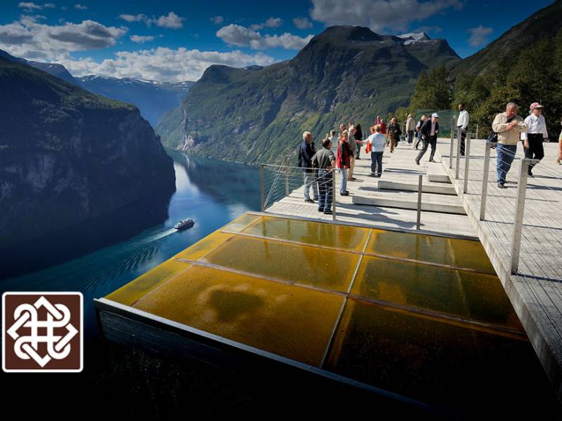
The drive along Trollstigen is undoubtedly more dramatic than most people are used to, but what is special about driving in Norway is that in fact people live just about everywhere. Even on the narrowest mountain ledge or small crag there will be a house. We are bound to the landscape and the natural surroundings through settlements that have offered us a livelihood throughout history. Geiranger-Trollstigen offers numerous highlights, and the eleven hairpin bends of Trollstigen as well as the view from Ørnesvingen down to the Geirangerfjord may set your pulse racing. Lush valleys, sheltered strawberry-growing areas, precipitous mountains and vantage points guaranteed to make you dizzy offer some of Norway’s most scenic views. Allow plenty of time for the trip − stops are welcome whether you want the challenge of a hike to a lofty summit or just to enjoy the view. For those who take the time, there’s such a lot more to be discovered.

Audio guides available in:
Norsk bokmål, English (British)

To find more content and listen to free audio guides, download the Voice of Norway app.

apple-storegoogle-play

Points of interest

#1

Linge

Linge is a village with a ferry connection between Åndalsnes and Geiranger. It is situated by Norddalsfjorden which is part of the fjord landscape between Storfjorden and Geirangerfjorden. The place is one of the northernmost with climatic conditions that allow fruits and nuts such as walnuts and peaches to be grown, but it is perhaps most well-known thanks to Martin Linge, the actor and member of the Resistance during World War II who grew up here. You can also see here a memorial dedicated to him. Eidsdal - Linge is a ferry connection on county road 63 and crosses Norddalsfjorden. The trip is 2.7 kilometres long and takes about 10 minutes. At Linge ferry terminal, there is a connection between county roads 650 and 63.

Audio guides available in:
Norsk bokmål, English (British)

#2

Eidsdal / Norddal / Herdalssetra

You are now on your way down to the agricultural village of Eidsdal in Møre og Romsdal County. The village has about 400 inhabitants. Eidsdal is on the south side of the Norddals Fjord. If you take county road 91 towards Norddal you can visit the beautiful Herdalen with Herdalssetra, which is above the village of Norddal and lies within the Unesco World Heritage Site. At the end of the plains you come to the unique Herdalssetra, which forms a dense cluster of more than 30 old mountain pasture farm houses. This is one of the largest communal mountain goat pastures in the country, and the traditional farming has stayed intact for more than 300 years. Here you may sample goat cheese and goat milk caramel that is made in the old fashioned way. It is also possible to stay overnight in farm houses, buy fishing licenses and hire a boat. The farm also has a simple cafe where sour cream porridge and cured meats are served throughout the summer season. Our journey proceeds by ferry across Norddalsfjorden to Linge. At Linge you have a choice of two routes onwards. One is to go to the strawberry valley of Valldal, and from there to the famous Trollstigen. This is one of the most famous tourist routes with 11 hairpin bends. The road continues towards Åndalsnes, which is the final station for the train from Oslo, and connects with the popular Rauma Railway from Dombås. But for us the journey on this route continues towards Ålesund.

Audio guides available in:
Norsk bokmål, English (British)

#3

Trollstigen

Trollstigen ('The Troll Ladder') ; is made up of eleven hairpin bends on county road 63 at the end of Isterdalen valley in the Rauma municipality. The Trollstigvegen road connects Valldal in Sunnmøre to Romsdalen and Rauma. The road is only open during the summer, usually from mid-May until the first snowfall in the autumn. After being under construction for almost eight years, the road was opened by King Haakon VII on July 31st 1936. The road was constructed following approximately the same path as a more ancient path called Kløvstien. This old traffic artery between Romsdal and Sunnmøre has been restored and signs have been put up, including signs indicating the footpath. The biggest challenge was the steep gradient at the edge of Isterdalen where the road zigzags its way up to Stigrøra. The eleven hairpin bends each have a radius of about 10 meters. Below the 180 metre high Stigfossen waterfall there is a bridge, and when the water flow is high, water splashes across the bridge. Because of repeated rock avalanches, especially in the winter, and parts of the road being destroyed, part of the road was rerouted in 2005. Two new bridges had to be built across the river Istra. The Trollstigvegen road is one of Norway's most visited tourist attractions. At the summit of Stigrøra, there is a large car park and a viewpoint.

Audio guides available in:
English (British), Norsk bokmål

#4

Stigfoss bridge

(Photo: wikipedia) You are now crossing the Stigfossbrua bridge on county road 63 which passes above the Stigfossen waterfall in Trollstigen. The bridge and the road were opened by King Haakon VII on July 31st 1936. The construction of the bridge started in 1933 and the construction of the walls was completed in 1934 and 1935. On one of the large stones put up along the side of the road, one can read "Stigfossbrua 1935" carved into the rock.

Audio guides available in:
Norsk bokmål, English (British)

#5

Trollstigen Cafe

(Photo: Reiulf Ramstad Arkitekter AS, Jiri Havran / Statens vegvesen) At the top of of the sharp turns from Isterdalen, you will find the Trollstigen plateu. Hre you will find a service building with a café, souvenir shops and toilet facilities. The café and shops are normally open from mid-May to September. By the service building there are beautiful water mirrors, bridges, and paths to the viewpoints where you can see the winding road, impressive waterfalls and the wild and stunning nature.

Audio guides available in:
Norsk bokmål, English (British)

#6

The Golden Route

Trollstigen is part of the Otta - Geiranger - Valldal - Åndalsnes - Dombås road which is called The Golden Route. Since 2005, Trollstigvegen has been one of the roads selected for the project National Tourist Routes. The project's slogan is Safe and Beautiful, meaning that all stops and picnic areas should look harmonious in relation to the nature and landscape. The road's highest point is 850 metres above sea level, at Alnesreset. This was the location of the restaurant Trollstigheimen which was destroyed by an avalanche. It was never rebuilt. The road was renovated between 2005 and 2009 in order to adapt to the increasing number of tourists. This included safety measures against stone avalanches, new rest stops and viewpoints, as well as souvenir shops. The traditional small huts that used to sell souvenirs were removed, at the same time as a new facility with a café and a souvenir shop opened in the summer of 2009. The road is surrounded by several mountain tops which are more than 1,000 metres high. Stigbotnhornet and Bispen are among the most famous. Dronninga and Kongen ('The Queen and The King') ; are to the north west. Trolltindene ('The Troll Peaks') ; with Trollklørne ('The Troll Claws') ;, and the backside of Trollveggen ('The Troll Wall') ; in the north east. The mountains and the many summits in Romsdal are popular among mountain climbers. There are several marked trails, most of which are quite easy to hike, while others require climbing.

Audio guides available in:
Norsk bokmål, English (British)

#7

Plattingen

(Photo: Per Kollstad, Jarle Wæhler / Statens vegvesen) Plattingen is the name of the platform that sticks out over the mountain edge and hovers 200 metres above Trollstigen. It provides a spectacular view of the majestic landscape. The platform has a different viewpoint depending on how brave or prudent you are. The construction is made of steel and glass, and protects against bad weather and winds. Plattingen was designed by architect Reiulf Ramstad Arkitekter AS. There is a short hike along the walking trails and stairs up to the viewpoints.

Audio guides available in:
Norsk bokmål, English (British)

#8

Geiranger-Trollstigen

(Photo: Steinar Skaar, Jarle Wæhler / Statens vegvesen) The drive across Trollstigen is without a doubt more dramatic than most are used to. One of the most striking observations one makes when driving around Norway is that there are actually people living everywhere. Even on the narrowest cliff or smallest hill it is possible to spot a house. This is how we are connected to the landscape and nature through settlements where people have lived their lives for generations before us. However, this will probably just be a digression since it is so easy to get lost in the spectacular landscape along this road. Geiranger - Trollstigen offers several highlights, and the drive up the eleven hairpin bends in Trollstigen or as you look out on the Geiranger fjord from Ørnesvingen will get your heart racing. Lush valleys, quiet strawberry villages, steep mountains and viewpoints provide both a sinking feeling and some of most beautiful sights in Norway. Plan plenty of time for the trip, the stops are valuable, whether you want to challenge yourself to a hike to the summit of a mountain or just enjoy the view. There is so much to discover if you take your time to do it. For hundreds of years, the Trollstigvegen road has been an important connection between Valldal and Åndalsnes. At first as a path, then as a horse trail until the construction of Trollstigvegen road started in 1916. Part of the original path is still visible today and it is still possible to walk on it. This is an interesting option for those who want to experience the path the way it was in the old days. Some of the most sensational spots in the area can be found here. The Ørnesvingen, Gudbrandsjuvet and Flydalsjuvet viewpoints allow a special experience of nature. With a ferry on the fjord, you can take a closer look at the famous De Sju Søstre (The Seven Sisters), Friaren (The Suitor) and Brudesløret (The Bridal Veil) waterfalls, and experience the world's most famous fjord, the Geiranger fjord, which is on UNESCO's list of world heritage sites.

Audio guides available in:
English (British), Norsk bokmål

#9

Juvet Landscape Hotel

The Juvet landscape hotel is walking distance from the Gudbrandsjuvet ravine. Its unique architecture and location have earned the hotel several awards. It has also been mentioned in multiple design and architecture magazines.

Audio guides available in:
Norsk bokmål, English (British)

#10

Gudbrandsjuvet

Gudbrandsjuvet is a ravine in the Valldøla river and is part of The National Tourist Route along county road 63 from Geiranger to Trollstigen. The gorge through which the Valldøla river passes is 5 metres wide and between 20 and 25 metres deep. The water has formed a system of potholes and intricate formations. The gorge is as deep below the water surface as above. According to a legend dating back to the 1500s, the ravine is named after a man called Gudbrand who ran off with a bride and escaped the groom by jumping across the ravine at its narrowest point. Gudbrand was declared an outlaw and spent the rest of his days in a stone hut in one of the sidevalleys above the ravine. That is how the valley got its name, Gudbrandsdalen, which is also its current name. The legend doesn't disclose whether or not he managed to take the bride with him across the ravine. There are good facililties to allow visitors to enjoy the view safely. There is also a café with an architectural style that matches the surrounding landscape.

Audio guides available in:
Norsk bokmål, English (British)

#11

Jordbærstova

Jordbærstova is located in the middle of the strawberry fields in Valldal. Here you can taste freshly picked strawberries, enjoy a nice meal, a good night's sleep or an exciting hike in the strawberry fields. Join a hike in the strawberry landscape and receive a tasty portion of local know-how. The hike takes about one hour and a reservation must be made a day in advance.

Audio guides available in:
Norsk bokmål, English (British)

#12

Valldal

Valldal is a beautiful village by the fjord, halfway between Åndalsnes and Geiranger. The valley stretches about 30 km from Storfjorden to the top of Trollstigen. Large parts of the valley consist of flat and low-lying grounds with ideal conditions for agriculture, and Valldal is known for its strawberries. Valldal has about 1,000 inhabitants concentrated in an area of 10 km along the fjord. Sylte by Storfjorden is the centre of Valldal and the centre of the Fjord municipality. Valldal is the closest neighbour to two important tourist destinations in Norway, Geirangerfjorden and Trollstigen. From Sylte, the county road continues through a tunnel to Fjørå and then to Tafjord. The road to Tafjord passes through a tunnel below the place where a crag fell down and caused the Tafjord accident in 1934. The big wave reached all the way to Valldal. In these areas you can try rafting, canyoning, spectacular mountain hiking and mountain climbing. You can rent ocean kayaks or spend the day at Valldal activity park for adults and children, a few kilometres in the direction of Trollstigen. The river Valldøla which runs through the valley, is ideal for rafting, but it is also a popular spot for salmon fishing.

Audio guides available in:
Norsk bokmål, English (British)

#13

Ørnesvingen

(Photo: Jarle Wæhler / Statens vegvesen) The Ørnesvingen viewpoint offers a splendid view. From here, you can see Geiranger, Geirangerfjorden, the De syv søstre (The Seven Sisters) waterfalls and the Knivsflå mountain farm. The platform itself was designed by architect Sixten Rahlff. The landscape architects were Smedsvig Landskapsarkitekter AS and artist May Elin Eikaas-Bjerk. Ørnesvingen is 620 metres above sea level and is at the top of the steepest part of the hillside from Geiranger with a gradient of 10%.

Audio guides available in:
Norsk bokmål, English (British)

#14

Ørnevegen

(Photo: wikipedia) Ørnevegen (The Eagle Road) is a section of county road 63 between Eidsdal and Geiranger, and has officially been a part of The National Tourist Route since 2012. The road stretches from the fjord at Grande to the mountain passage by Korsmyra and consists of 11 sharp turns, winding upwards along the steep mountain side. Ørnevegen got its name because of the many eagles in the area, especially around the highest turn, called Ørnesvingen. The road was first opened in 1955, and underwent considerable restoration and modernisation in 2012. Before that, the access to Geiranger, was by boat from Valldal and Eidsdal. Ørnevegen is now open all year round, and is the only road connection to Geiranger in the winter time, but it can sometimes be closed for shorter periods when there is a risk of an avalanche. The road has its limitations, for example, the maximum length of a vehicle is 15 metres, only a metre longer than today's buses. Some car manufacturers have used the road to test their newest car models' capacity to drive in winter conditions.

Audio guides available in:
Norsk bokmål, English (British)

#15

Eidsdal

(Photo: Jarle Wæhler / Statens vegvesen) Soon we arrive at the small, charming village of Eidsdal, which lies on the south side of the Norddalsfjord. Eidsdal is primarily an agricultural village and most of the farmers run milk production from cows and goats. Here there is a ferry to Linge that takes you on to Ålesund or Tafjord and Trollstigen. The road up the valley goes to Geiranger and is part of the national tourist road Geiranger-Trollstigen. There is also a narrow road along the fjord that takes you to Norddal and on to the well-known tourist destination, Herdalssetra. There you can enjoy the mountainlife in beautiful surroundings as it has been for several hundreds of years.

Audio guides available in:
Norsk bokmål, English (British)