Atlanterhavsvegen utsikt

Norwegian Scenic Route Atlanterhavsvegen

Provided by:

Nasjonale turistveger

Placeholder image

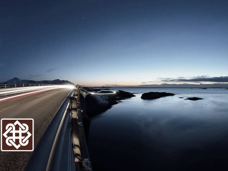
Nothing is as mighty as the ocean ‒ our most important transport route for centuries, a source of income and the starting point for innumerable recreational options. Few places bring you closer to the ocean and let you feel part of it in the same way as Atlanterhavsvegen. Here you will feel the effects of winter storms and enjoy days of sunshine in the summer. The road is a visual delight as it curves elegantly from islet to islet over its seven bridges. The natural surroundings and feats of modern engineering combine to create a unique driving experience. The trip takes you from the fertile cultural landscape of the coast across moorland to bare crags along the weather-beaten, open bay of Hustadvika.Take time to watch the sun disappearing below the horizon from here. Atlanterhavsvegen has been described as the world’s most beautiful car drive. It is an intense experience that will give you an insight into a harsh world where you must withstand a gust of wind.

Audio guides available in:
Norsk bokmål, English (British)

To find more content and listen to free audio guides, download the Voice of Norway app.

apple-storegoogle-play

Points of interest

#1

Kårvåg

Photo: Jarle Wæhler / Statens vegvesen Kårvåg is a village of about 300 inhabitants on Averøy island, near the Atlantic Road. It has a primary school, a kindergarten, a petrol station, retail outlets, shops and restaurants.

Audio guides available in:
Norsk bokmål, English (British)

#2

Håholmen

(Photo: Grete Kongshaug / Statens vegvesen) Håholmen has been a fishing village focused on klippfisk (dried and salted cod) since the early 1700s and was initially a dynamic community based on trade, fishing and maritime transport. Håholmen Sea Cottages today include a hotel, a conference centre, a café and a restaurant where guests move freely between the buildings — just like people did traditionally in vibrant fishermen's communities. Håholmen has a heritage worth preserving — this used to be a central meeting place for fishermen, sailors, salesmen and travellers. Its history and location on one of the most unsheltered parts of the Norwegian coastline adds to the unique character of the island. To a great extent, the 25 buildings have remained largely unchanged since the 18th and 19th centuries. This island of merely 50,000 m2 creates a natural separation between the open sea and the shipping lane on the outside. The landside of the island provides a beautiful natural harbour, protected from all kinds of weather. It was the adventurer Ragnar Thorseth and his wife Kari, who first came up with the idea of turning Håholmen into a hotel and conference centre. Together, they ran Håholmen until 1998. The Hall of Saga Siglar houses the Viking ship Saga Siglar, which Thorset used to circumnavigate the globe, and numerous souvenirs from this and other adventures. Exhibitions about old and recent history of Håholmen are also gathered here. The visit ends with a viewing of a film about Ragnar Thorseth's many adventures. The island is only accessible by boat. Check out the link if you want to book a hotel room, a table or just a ride across to visit the island.

Audio guides available in:
Norsk bokmål, English (British)

#3

Eldhusøya

Photo: Harald Christian Eiken, Jiri Havran / Statens vegvesen The walking path around Eldhusøya island offers a splendid view. The path is suitable for everyone and is open every day, all year round. Don't let bad weather stop you since experiences in bad weather can be at least as intense as in good weather. The café is normally open during the summer season, but to be sure please check the link in the app.

Audio guides available in:
Norsk bokmål, English (British)

#4

Storseisundbrua

Photo: Harald Christian Eiken, Magne Flemsæter, Jiri Havran \ Statens vegvesen The Storseisund Bridge is the longest and perhaps most well-known of the 8 bridges of the Atlantic Road. The bridge is a cantilever bridge with a length of 260 metres and largest span of 130 metres. It is among the most iconic tourist attractions in Norway, and is frequently used in commercials, films, etc. The BBC's popular series Top Gear has also filmed an episode on this bridge and the Atlantic Road.

Audio guides available in:
Norsk bokmål, English (British)

#5

Atlantic road

Photo: Jarle Wæhler / Statens vegvesen The Atlantic Road runs along a stretch of sea at the very edge of the Atlantic Ocean, offering a scenic drive across the many bridges and islands. Often described as the world's most beautiful road trip, this section of County Road 64 is part of the National Tourist Route stretching from Vevang in Eide to Kårvåg on Averøy. The construction of the Atlantic Road began in 1983 and was completed in the summer of 1989. In 2005 it was voted Construction of the 20th Century. The road replaced the ferry route between Ørjavik and Tøvik which until then had connected the two municipalities. The entire installation, more than 8 km long and consisting of eight bridges with a combined length of 891 metres, runs across multiple islets and reefs. The Atlantic Road ranks number 8 of the most visited nature-based tourist attractions in the country, with several hundred thousand visitors each year. The road has also been the setting for numerous commercials, and several car producers — among which Lamborghini — have filmed commercials here to promote their latest models. The entire National Tourist Route called the Atlantic Road is 36 km long and connects Kårvåg to Bud. The road offers a unique experience with its breathtaking coastline and original design, both of the road itself, the bridges and multiple installations along the way. This place is equally spectacular to visit in inclement and windy weather, as it is on a bright and sunny day. Look west, towards the vast open sea and Hustadvika, a stretch of the Norwegian Sea known for its many reefs and dramatic climate. In calmer weather, it is possible to spot both seals and whales in the area. Between Vevang and Bud, southeast of the Atlantic Road, experience the lush coastal landscape with heaths and bare rocks along the unsheltered and open coastline of Hustadvika. The experience is intense and provides an insight into a region exposed to many different types of weather: here you risk facing strong winds, or – when the weather is good – a sunset that will leave a lasting impression on your mind.

Audio guides available in:
Norsk bokmål, English (British)

#6

Myrbærholmbrua

Photo: Jarle Wæhler / Statens vegvesen The Myrbærholm Bridge connects Skarvøya to Eldhusøya via Flatskjæret. In 2010, bridges specially dedicated to fishing opened on Myrbærholmen. From these you could try to catch some fish from the famous Atlantic Road. Unfortunately, there is no option to rent fishing gear here at the moment, so you would need to bring your own. Or you could watch other people fish here. In the strong tidal currents, there is a good chance of catching cod, pollock, mackerel and saithe from the clear waters.

Audio guides available in:
Norsk bokmål, English (British)

#7

Skarvøya

(Drawing: Ragnhild Folland) You are now on Skarvøya island. Together with Strømsholmen islet, this is the most southwesterly island on the Atlantic Road. Here you will find Gallery Skarvøya with a small café — a perfect pit stop to stretch your legs and admire the view.

Audio guides available in:
Norsk bokmål, English (British)

#8

Strømsholmen Seasport Center

Photo: stromsholmen.no Strømsholmen Sjøsportsenter (Strømsholmen Sea Sports Centre), is a place for adventures above and below the water. Since 1981, the professional dive center Strømsholmen offered a unique blend of thrilling adventures to visitors from around the world. The Sea Sports Centre is situated on the Atlantic Road and offers accommodation, fishing, diving, seal safaris, sightseeing tours etc.

Audio guides available in:
Norsk bokmål, English (British)