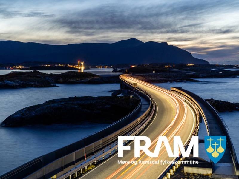
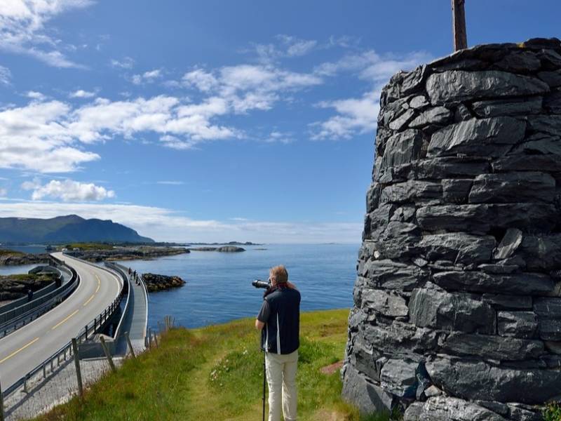
Points of interest

#1

Åndalsnes

Here, surrounded by majestic mountains, deep and lush valleys and emerald green rivers, lies Åndalsnes, or Tindebyen which is full of spectacular experiences. The town was also at the centre of one of the second world war’s largest battles, during which the whole of Norway’s gold reserve was at stake. In dramatic fashion, Norwegian and English soldiers together with hundreds of heroic volunteers managed to save the Norwegian gold and cash reserves, whilst howling German bombs squealed around them leaving the whole town in ruins. Both the town and the steadfast people rose up again and to this day exist as a hub between the fantastic Norwegian mountain experiences both in Summer and Wintertime. The idyllic fjord centre has all you need and more. We recommend the spectacular walk up the Romsdalstrappene to the Rampestreken viewpoint, which literally hangs out 8 meters in the air, giving you an eagle’s eye view over Åndalsnes and the beautiful Romasdal fjord. On your way down again we recommend taking the award winning Romsdal Gondola for all of you without a fear of heights. And if you should hear some rough guitar riffs or some banging dance tunes, then maybe Raumarock or another of Åndalsnes’ famous music festivals is taking place.

Audio guides available in:
Norsk bokmål, English (British)

#2

Fannefjord tunnel

For as long as people have lived here, they have had to cross over the fjord to do errands, conduct business, and visit their relatives and friends. The fjords were the main thoroughfares in the past, and boats of different sizes were the means of transport. As vehicles became more common, car ferries came into use. Commercial, private and tourist traffic have increased over the years. Ferry transport is no longer a sufficient option on some fjord routes, so in recent years both bridges and tunnels have been built. The Fannefjord tunnel on the FV 64 road goes under Fannefjord near Årø, between Molde and Bolsøya. At its deepest, the tunnel sinks to 101 metres below sea level. It is 2743 metres long and its steepest gradient is 10%. The tunnel was opened as a toll road in 1991, and financing of the costs was covered by 2005. The tunnel is part of Skålavegen (Skåla Road), which was a replacement for the ferry routes Molde-Bolsøya and Lønset-Grønnes.

Audio guides available in:
Norsk bokmål, English (British)

#3

Bolsøy Bridge

Between Bolsøya and Grønneset, on the mainland, the Bolsøy Bridge crosses Bolsøysundet. The bridge was opened in 1991 as part of Skålavegen (Skåla Road). This is a 555 metre-high concrete beam bridge. It has 11 spans, the longest of which is 55 metres. The maximum clearance height from the sea is 16 metres. What is the view from the bridge on a clear day? To the south, you can see the majestic Romsdalsfjella and to the north, Fannefjord. Driving across the bridge can be tough if there is heavy wind and rainfall. It has become popular to dive at the Bolsøy Bridge, especially at night, because the marine wildlife is more abundant at night than during the day. Here you can see pollack, cod and eel, as well as eight-armed squid, sea sausages, crayfish and lobsters. Dead man's fingers grow underwater on the bridge pillars. The current can be strong here in the channel. A song was written about the Bolsøysund Bridge in 1994. The lyrics are by Leif Bjarne Fylling, who was from Grønnes. There four verses, but the last verse contains the line: "There is a bridge over Bolsøysundet where stormy waters often flow, it is a tie that binds the new to the olden days."

Audio guides available in:
Norsk bokmål, English (British)

#4

Røvik Church

Røvik Church is located in Røvik on the Skåla Peninsula. The church was inaugurated in 1905. This is a long Swiss-style church, a typical style for the period. It has seating for 280 people. The architect was Gabriel Smith, who also designed Røbekk church. Bolsøy parish was divided in 1896, and Røvik became a parish in its own right. Until 1905, the old church on Bolsøya was the parish church. But from then on Røvik church became the parish church, and the church on Bolsøya was demolished in 1907. The inventory from the old Bolsøy church was transferred to Røvik church. The items that were moved included an altarpiece, baptismal font, pulpit and church bells. The altarpiece was carved by a local artist in 1730. The architecture of this church is in an updated style from the early 1900s, but the church interior has retained its traditional form.

Audio guides available in:
Norsk bokmål, English (British)

#5

Grand Hotel Bellevue Andalsnes

Åndalsnes has been a port for cruise ships since 1883, attracting tourists interested in salmon fishing and rock climbing and drawn by the magnificent views. Over time, tourism grew and the need for more accommodation became pressing. The Grand Hotel was built in 1890; by this stage, tourism was already an important industry here. Guests can still soak up the historic atmosphere of the hotel, even though it has been revamped and rebuilt at several stages. There are historical photographs on display on all floors of the hotel, and some of the rooms are decorated with wall-sized photographs from days gone by. There are also photographs of celebrity guests who have stayed here. Åndalsnes was bombed in 1940 and the hotel was burnt down. It was later rebuilt, and stands in about the same location as it was originally. The hotel currently has 86 rooms. The views from the hotel, which is located in the center of Åndalsnes, are breathtaking.

Audio guides available in:
Norsk bokmål, English (British)

#6

Veøy old church

The old church on Veøy is located in Veøy and Røvik parish in the municipality of Molde. This church is also called St. Peter's Church, because it was dedicated to St. Peter. The building is a medieval church built in stone. It was built around the year 1200 and it is a listed building. The earliest written record of Veøy old church is in a will from 1309. The church is a ‘langkirke’ (long church) with seating for 400 people. The name Veøy itself means ‘holy island’. During the Viking era, Veøy was a market town - a trading center - and Veøy was an important hub in Romsdalen until the late 1600s. Veøy church has been a county church for the entire area, and it served as a parish church until 1907. The church is built in Romanesque style with round arches. Both exterior and interior walls are whitewashed. The interior dates from the 17th century, and at that time Veøy old church had income from 88 farms and was considered one of the richest churches in Norway. This church provided funds for the restoration of Nidaros Cathedral. The parsonage dates from 1742 and is also listed. Veøy is one of the key stages along the coastal pilgrimage trail from Egersund to Trondheim. There is a guided tour in cooperation with Romsdal Museum each summer.

Audio guides available in:
English (British), Norsk bokmål

#7

Sølsnes farm

As a child, and again as a pensioner, this was the home of the now largely forgotten Norwegian adventurer, businessman and consul Jonas Marius Lied. He lived from 1881 to 1969 and was a diplomat and an industrial entrepreneur. He was a collector of Russian art, and at Lied's family farm one can see art treasures from the Tsarist era in Russia. His life was, to put it mildly, an adventurous one, and from 1910 to 1931 he was involved in various enterprises in the USSR/Russia. Lied had one main project: The Siberian Company, founded in Oslo in 1912. He opened an Arctic sea route between Western Europe, via the Arctic Ocean and Asian Russia, to the interior of Siberia. Success was assured when Fridtjof Nansen agreed in 1913 to participate in Lied's second expedition from Tromsø to Siberia. Nansen portrayed this journey in his book ‘Through Siberia’. But the company's property was confiscated by the Bolsheviks in 1918. From 1914, Lied was Norwegian consul in Krasnoyarsk, and was named ‘hereditary Russian citizen of honor’ by Tsar Nicolas II. Lied then settled in London, but in 1920 he returned to the Soviet Union, this time as an international businessman. In the 1920s he bought many Russian paintings and prints. He worked as Senior Vice President of the Canadian company, Aluminum Union Limited, until he retired to Romsdal on retirement. He wrote two books about his dramatic life – ‘Over the High Mountains’ and ‘Birth of A Sea Road’.

Audio guides available in:
Norsk bokmål, English (British)

#8

Veøy Church

Veøy church, situated by the bend near Sølsnes Ferry Quay, is a ‘long church’ in wood, and it was erected in 1907. Many such churches were built in the early 1900s. The church is a long dragon-style church. ‘Langkirke’ means that the main room is large, while the trancepts have a lower ceiling height in relation to the nave. The dragon style was an architectural design intended to express national independence and uniqueness. This was important in the years following Norway's liberation from Sweden in 1905. The church is built of notched beams with a panelled exterior. The church is painted red, but most churches from this period are white-painted. Inside, the colours are light ochre with darker browns on the skirting boards and moldings. There is seating for 212 people in the church. The architect was Karl Norum.

Audio guides available in:
Norsk bokmål, English (British)

#9

Bolsøya - Vardholmen (age limit 18 years)

Vardholmen is located just north of Bolsøya. It is an old court where death sentences were carried out. The last execution in Norway was in 1876. In the 18th century, the death sentence was commonly applied in cases of the killing of children born out of wedlock. Here in Romsdal are recorded several such judgments from about 1780. But before those convicted were executed, they were often tortured. They were mutilated with glowing tongs, and had their arms and legs cut off before being beheaded with an axe. After death, the corpses were affixed to wheels, and these wheels were put on stakes and then exhibited for a long time to terrify and warn people passing by. Vardholmen was a court in 1777 when Anne Echerhagen was executed by beheading here. She had killed her husband in 1775, but as she was pregnant, they had to wait until the innocent child was born before they could execute Anne. She was convicted of having added arsenic to her husband's liquor, which, unsurprisingly, killed him. Before the execution itself, she was tortured and had her right hand cut off. After the execution, both her head and her hand were put on a stake. The remains of Anne Echerhagen were on display for a long time at Vardholmen.

Audio guides available in:
Norsk bokmål, English (British)

#10

Rødven stave church

Rødven Stave Church is a medieval stave church at the Rødven farm. There are only two medieval churches in Romsdal today, at Veøy and Rødven. When Rødven Stave Church was built is somewhat uncertain, but experts believe it dates from around the year 1300. Inside the church there is a crucifix in actual body size, and this has been dated to the latter part of the 13th century. Rødven stave church is supported by eight posts. There are weatherboards on the exterior and the roof is of stone today, making the church untypical among Norway's most famous stave churches. But once inside, one can clearly see that this is a stave church. One can see the characteristic features of stave construction, with posts and beams forming frames that are filled in with upright planks. There are also runes inscribed in the woodwork, which say: ‘Øystein wrote. To God I will’. The decorations inside the church were probably made in the first half of the 17th century. The altarpiece and pulpit are from 1712. The church has been restored repeatedly after suffering damage by storms and woodpeckers. It was in use until 1907. The following year, it became a listed monument. Today, the church is used for special occasions such as baptisms and weddings.

Audio guides available in:
Norsk bokmål, English (British)

#11

Norwegian Mountaineering Center

Norsk Tindesenter attracts mountain climbers and regular tourists alike. Its main focus is on Norway's mountaineering history. Inside the center, you can start your visit with a cinematic experience allowing for floor-to-ceiling movie viewing. Here, stunning trekking films combined with short historical narratives take you on an exciting adventure trip. The center has a number of interesting installations showing different aspects of the climbing sport, and the driving forces motivating mountaineers. Both children and adults are invited to learn and participate interactively. Real stories have been dramatized and old equipment displayed alongside so you can study the challenges of the climbing pioneers. If you feel up to it, you can test your own climbing skills. Norway's highest indoor climbing wall – Carl's Hall – is here at Norsk Tindesenter. It has routes up to 21 meters. Norsk Tindesenter also has its own children's bouldering cave suitable for children from 3 years of age and upwards.

Audio guides available in:
English (British), Norsk bokmål

#12

The Sølsnes - Åfarnes ferry route

The Sølsnes - Åfarnes ferry route was opened for car traffic in 1931. At that time, the ferry took only 4-5 passenger cars at a time, and one had to book in advance as there was not yet a regular timetable here. In the 1930s, about 1,000 cars were transported each year. During the occupation of 1940-1945 the ferry was out of commission. Today, this crossing is much busier, and right here is where the world's first gas-powered ferry was taken into use. This ferry route also had an important role to play in WWII. Norway's gold reserves of 49 tonnes were transported from The Bank of Norway in Oslo to Dombås and down Romsdalen valley to the Romsdal coast. At Åndalsnes, the gold was loaded from railway wagons onto lorries. The gold was headed for Molde for further transportation, out of Norway and into safe hands. This involved a dramatic race against time, as the Germans were not far behind the lorry convoy, bombing several cities, towns and quay areas in the area. The lorries with the gold had to get up a very steep hill from the quay at Sølsnes, as the quay was a few metres further west of its present location. The situation was made more dramatic by the fact that the ferries could not take many lorries at a time. Two ferries were requisitioned, and it took six hours to transport all of the lorries across. The ferries had to go back and forth countless times. The happy result was that Norway's gold holdings were saved, taken via England to the USA and Canada.

Audio guides available in:
Norsk bokmål, English (British)

#13

Isfjorden - History of clothing

Isfjorden is often referred to as the cradle of the fashion industry in Norway. Here, production of ready-made clothing was already happening in the 1860s, quite uniquely for that time. Trondheim and Bergen had lost their exclusive right to trade in Northern Norway at the beginning of the 19th century, which opened up the market to other districts. The inhabitants of Isfjorden seized their chance. They began selling ready-made clothing and shoes to fishermen along the coast. This trade became known as Nordlandhandel (Nordland trade). It started with small factories and workshops, but eventually larger factories grew, and the clothing industry flourished. One of the pioneers of the industry was Knut Mestad Hatlen. Another well-known clothing factory was Oddfred Tokle's, which operated from 1938 to 1982. The Nordland trade laid the foundation for the development of the clothing industry in Romsdal, and it became important in a national context as well. Around 1950, 55% of the workforce in the Isfjorden worked in clothes production. Why did this industry flourish right here? There are several reasons. There were raw materials, such as wool and leather; labour was available, together with long experience and professional knowledge; and there were people with enough capital to invest. The geographical location was favourable for transporting goods both south and north by sea, and to eastern Norway across the mountains. In April 1940, the factories in Isdalen managed to quickly switch production to large quantities of white camouflage clothing for Norwegian soldiers, who were fighting against German invasion.

Audio guides available in:
Norsk bokmål, English (British)

#14

Trollpila - The Trollarrow

Bolsøy was an important farm in the Iron Age and the Middle Ages. The obelisk ‘Trollpila’ on the farm is visible evidence of that. Such standing stones were often to be found on large, central farms. This farm early on became a church site in the Middle Ages, which in itself indicates that a prominent family lived here. Trollpila is about five meters long, narrow and thin and resembles a large arrow. The stone is one of Norway's tallest standing stones. There is a legend attached to Trollpila, which the playwright Henrik Ibsen recorded. The legend says that Olav the Saint anchored his ships at Bolsøya. He thought it a suitable place to set up a church. Rumors that a church was being built reached a female troll up the Skåla mountain, about a mile away. She strongly disapproved of this churchbuilding, and decided to put an end to it. When the church was almost finished, she shot an arrow at it. The arrow did not reach its target, but remained planted in the ground some distance from the cemetery. The troll’s arrow (‘trollpila’) remains where it landed to this day.

Audio guides available in:
Norsk bokmål, English (British)

#15

Isfjorden - Vengedalen and Romsdalseggen

Romsdalseggen is reminiscent of a huge cock’s comb, with its spikes rising high into the sky. The mountain ridge consists of several peaks and is 10 km long. Vengedalen is the starting point for the trip over Romsdalseggen. There is a daily bus from Åndalsnes to Vengedalen, there and back, between July 1 and September 30, or you can go with your own car. The trip over Romsdalseggen is not too tasking, but one should be in good physical shape and have the right equipment. It rises 970 metres and is graded ‘red’. If the weather is bad, the trip is not recommended. It takes about 8 hours to walk across Romsdalseggen, which is a marked trail with steel steps at some of the more difficult stages. It can be difficult to ascend, but once you get up to Romsdalseggen you are rewarded with an impressive view of the mountains in Romsdal. From here you can see the Troll Wall (Trollveggen), Romsdalshorn, the King (Kongen), the Queen (Dronningen), the Great Trolltind and the Great Venjestind. From the peak you can also see out to sea, and to the town of Molde. Below, in Romsdalen, you can see the river Rauma. The highest point of the tour reaches 1216 metres above sea level. In 2011, Lonely Planet called Romsdalseggen one of the most beautiful mountain hikes in the world.

Audio guides available in:
Norsk bokmål, English (British)

#16

Moldegård

(Photo: Romsdalsmuseet / Digitalt Museum, moldegaard.com) In front you now, you can see Moldegård. Originally, the estate was called Molde, supposedly from Norse "moldar", plural for "mold". Molde became the home of Captain Johan Fredrik von Beverlov, commander of the Romsdal military Company. He settled there and acquired the main farm, in approximately 1677. During his time, the suffix -gård (literally "farm") was used to differentiate between the growing town and the surrounding farms, including Reknes. Moldegård was the County Governor's house from 1705 to 1729, in addition to two short periods in the 1750s, and was supposedly the inspiration for Ibsen's 1886 drama Rosmersholm. The main farm house has been the property of the Møller family since 1789 and was registered in the cadastre of Bolsøy until the two municipalities were joined in 1964.

Audio guides available in:
Norsk bokmål, English (British), 日本語, Deutsch , Español

#17

Bolsøy Bay

On beautiful Bolsøya there are many cultural monuments. It is likely that a powerful chief lived here, and there is a meeting place, or ‘tingsted’ that can be traced back to the Viking age. Viking graves, of two women and one man, were discovered at Tingneset in 1922, and there are burial mounds from the same period in several places on the island. In addition, a treasure trove from the Viking Age was found buried here on the island in 1847. It was probably buried around the year 1000. The treasure consists of three large silver rings. It was common for Vikings to melt down foreign silver coins in order to make jewellery. These three silver rings are made in Scandinavia. There was a medieval church a little further inland on the island. The church was rebuilt several times, but in 1906 it was demolished and removed. Remains of the church are still visible, and its cemeteries remain upkept. It is said that the church was built on the orders of Saint Olav (Olav Haraldsson) after he supposedly visited Bolsøya. Traces of the boathouse which housed the chieftain’s large ship, and/or a leidang ship, can be seen a few metres north of the road as it nears the Bolsøy bridge. The latter type of ship was used for defensive purposes in the period from about 800 AD to the 15th century. The ship in this case was probably about 14 metres long and 4 metres wide. Such vessels commonly had at least 20 rowers, and twice as many fighters, on board. The sail of the leidang ship was stored in the nearest church; in this case, the church here on the island. The Hansa burned down the boathouse in the 1300s or 1400s.

Audio guides available in:
Norsk bokmål, English (British)

#18

Mountain history of Romsdalen

At the end of the 19th century, horse-drawn carriages carrying English tourists were a common sight in Romsdal. A 19th-century tourist reportedly said of Romsdalen that it was ‘an Eldorado that beats both Switzerland and California!’ The first tourist boats were English, and both sail and steam powered. Emperor Wilhelm II of Germany visited Romsdalen frequently in the period from 1889 to 1914. The emperor expressed his enthusiasm for these magnificent landscapes. His ship, SMS Hohenzollern, visited Romsdal each year until 1914. Wilhelm II was known as a ‘friend of Norway’, and in 1905 he played an important role in persuading the Swedish king, Oscar II, not to attack Norway. There was a danger that Sweden would attack in reaction to Norway's declaration of independence from Sweden in 1905. The mountains of Romsdal have attracted mountaineers for more than a hundred years. Many considered it impossible to climb Trollveggen, which with its 1000 metres is Europe's tallest vertical mountain wall. But in 1965, climbers managed to scale it. It took 14 days for them to complete the climb. From 1980, base jumping became popular here. Several parachutists died and many were injured in these jumps, and in 1986 the activity was prohibited.

Audio guides available in:
Norsk bokmål, English (British)

#19

Eldhusøya

Photo: Harald Christian Eiken, Jiri Havran / Statens vegvesen The walking path around Eldhusøya island offers a splendid view. The path is suitable for everyone and is open every day, all year round. Don't let bad weather stop you since experiences in bad weather can be at least as intense as in good weather. The café is normally open during the summer season, but to be sure please check the link in the app.

Audio guides available in:
Norsk bokmål, English (British)

#20

Storseisundbrua

Photo: Harald Christian Eiken, Magne Flemsæter, Jiri Havran \ Statens vegvesen The Storseisund Bridge is the longest and perhaps most well-known of the 8 bridges of the Atlantic Road. The bridge is a cantilever bridge with a length of 260 metres and largest span of 130 metres. It is among the most iconic tourist attractions in Norway, and is frequently used in commercials, films, etc. The BBC's popular series Top Gear has also filmed an episode on this bridge and the Atlantic Road.

Audio guides available in:
Norsk bokmål, English (British)

#21

Atlantic road

Photo: Jarle Wæhler / Statens vegvesen The Atlantic Road runs along a stretch of sea at the very edge of the Atlantic Ocean, offering a scenic drive across the many bridges and islands. Often described as the world's most beautiful road trip, this section of County Road 64 is part of the National Tourist Route stretching from Vevang in Eide to Kårvåg on Averøy. The construction of the Atlantic Road began in 1983 and was completed in the summer of 1989. In 2005 it was voted Construction of the 20th Century. The road replaced the ferry route between Ørjavik and Tøvik which until then had connected the two municipalities. The entire installation, more than 8 km long and consisting of eight bridges with a combined length of 891 metres, runs across multiple islets and reefs. The Atlantic Road ranks number 8 of the most visited nature-based tourist attractions in the country, with several hundred thousand visitors each year. The road has also been the setting for numerous commercials, and several car producers — among which Lamborghini — have filmed commercials here to promote their latest models. The entire National Tourist Route called the Atlantic Road is 36 km long and connects Kårvåg to Bud. The road offers a unique experience with its breathtaking coastline and original design, both of the road itself, the bridges and multiple installations along the way. 
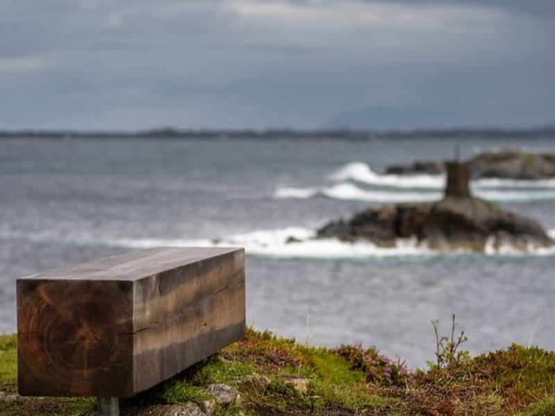
This place is equally spectacular to visit in inclement and windy weather, as it is on a bright and sunny day. 
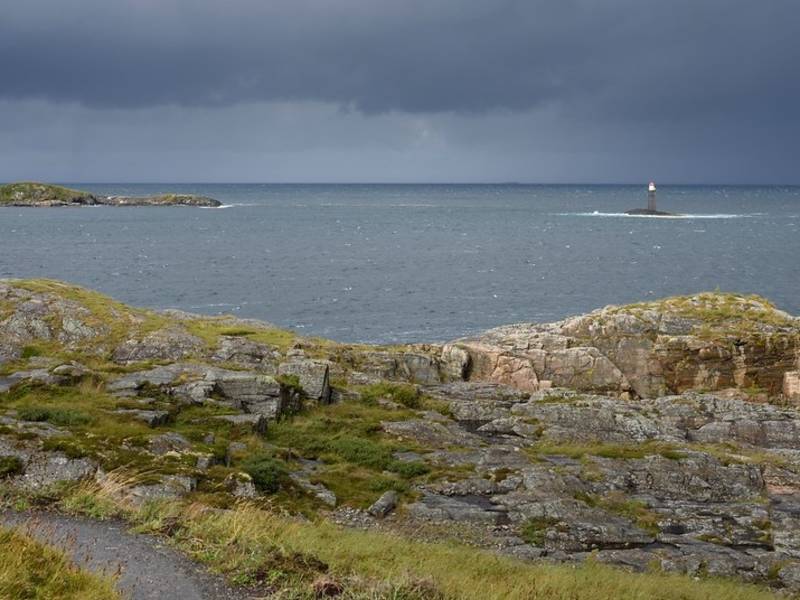
Look west, towards the vast open sea and Hustadvika, a stretch of the Norwegian Sea known for its many reefs and dramatic climate. In calmer weather, it is possible to spot both seals and whales in the area. 
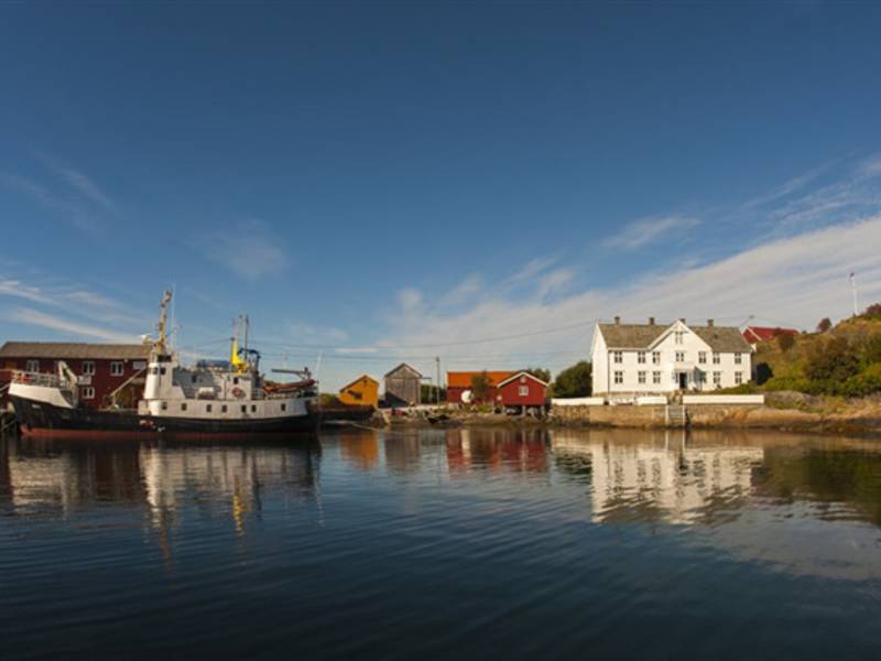
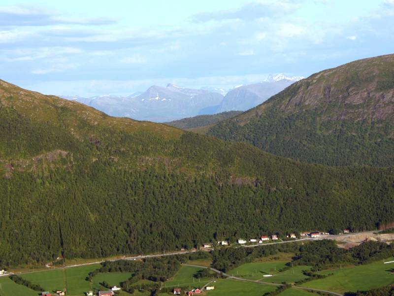
Between Vevang and Bud, southeast of the Atlantic Road, experience the lush coastal landscape with heaths and bare rocks along the unsheltered and open coastline of Hustadvika. The experience is intense and provides an insight into a region exposed to many different types of weather: here you risk facing strong winds, or – when the weather is good – a sunset that will leave a lasting impression on your mind.

Audio guides available in:
Norsk bokmål, English (British)

#22

Myrbærholmbrua

Photo: Jarle Wæhler / Statens vegvesen The Myrbærholm Bridge connects Skarvøya to Eldhusøya via Flatskjæret. In 2010, bridges specially dedicated to fishing opened on Myrbærholmen. From these you could try to catch some fish from the famous Atlantic Road. Unfortunately, there is no option to rent fishing gear here at the moment, so you would need to bring your own. Or you could watch other people fish here. In the strong tidal currents, there is a good chance of catching cod, pollock, mackerel and saithe from the clear waters.

Audio guides available in:
Norsk bokmål, English (British)

#23

Skarvøya

(Drawing: Ragnhild Folland) You are now on Skarvøya island. Together with Strømsholmen islet, this is the most southwesterly island on the Atlantic Road. Here you will find Gallery Skarvøya with a small café — a perfect pit stop to stretch your legs and admire the view.

Audio guides available in:
Norsk bokmål, English (British)

#24

Strømsholmen Seasport Center

Photo: stromsholmen.no Strømsholmen Sjøsportsenter (Strømsholmen Sea Sports Centre), is a place for adventures above and below the water. Since 1981, the professional dive center Strømsholmen offered a unique blend of thrilling adventures to visitors from around the world. The Sea Sports Centre is situated on the Atlantic Road and offers accommodation, fishing, diving, seal safaris, sightseeing tours etc.

Audio guides available in:
Norsk bokmål, English (British)

#25

Årø Airport

(Photo: fjordnorway.com) Molde’s airport Årø was financed by the Molde municipality and inaugurated in 1972. A lengthy discussion whether there should be a common airport for Romsdal and Nordmøre ended with the development of two airports, one in Molde, the other in Kristiansund. Årø serves more than 500,000 passengers annually. Fylkesvei 64 goes through the Fannefjord tunnel just under the runway. Over time the airport has undergone a series of improvements to meet the needs of both leisure and business travelers. The largest development was the extension of the runway from 1601 to 1980 meters. The additional runway was added during summer 2008.

Audio guides available in:
Norsk bokmål, English (British)

#26

Malme

The village Malme has about 500 inhabitants located at the end of Malmefjorden, the innermost part of Frænfjorden. The village has a significant production facility for refrigeration systems used in industry, fishing, and aquaculture. The name Malme comes from the Norse name "Malmr", which means 'sandy moor' or 'gravel field'. The fjord is a favorite place for ice skating fans. As the fjord freezes over during winter, it turns into a fantastic skating rink which extends for several kilometers. When conditions are safe, it is possible to spend many hours on the ice and enjoy both nature and the food you bring along for a nice day out.

Audio guides available in:
English (British), Norsk bokmål

#27

Sylte

The village Sylte has just a little over 300 inhabitants. It is located next to Sylteelva about six kilometers east of the city center of Elnesvågen (Fræna municipality). Here you will find a residential area surrounded by farmland looking down toward Sylteosen and Fræneide, and a shieling cottage up toward Kvannfjellet, the highest mountain in Fræna municipality. Sylte has its own elementary school, linked with Malme School, four kilometres away. First to fourth graders attend Sylte School, while fifth to seventh graders go to Malme School. Sylteelva is a popular destination for anglers.

Audio guides available in:
Norsk bokmål, English (British)

#28

Bergtatt adventures

(Photo: fjordnorway.com) We are now not far away from a 40 km system of mining tunnels that penetrate Bergtatt mountain on eleven levels. The mining operations started here in 1938, providing marble for the paper industry in Norway and Sweden. A few years ago the idea arose to open parts of the mountain as a tourist attraction. Within a short time this plan was implented. Bergtatt, also called «Fjellets mørke – the darkness of the mountain» - is already a reality. A trip to Bergtatt begins in daylight as you travel up the mountain side. When you reach the entrance to the mine, the road disappears into the big tunnel leading you further inward. For a while you will be surrounded by darkness before you get a glimpse of distant light. You can then board a barge resting on water that is glass-clear. As you proceed it gets darker before something lights up in front of you. Then quite suddenly four large chandeliers illuminate the marbled walls of a troll cave with plenty of space for both audience and artists. You are guaranteed to have an unforgettable experience at Bergtatt.

Audio guides available in:
Norsk bokmål, English (British)

#29

Eide Church

(Photo: Visit Norway) Eide Church is an aisleless “long church” completed in 1871. It is a wooden building with seats for 340 people. The church organ was made in Norway by Norsk Orgel og Harmoniumfabrikk. The organ’s pipes have sounded since 1977. The chimes of the church bells are much older. They started ringing in 1871. Then as now entrepreneurs understand the value of sponsoring – an inscription in one of the bells says: „Given by Kristiansund Sparebank 1871“. Around 3500 people live in this church’s parish.

Audio guides available in:
Norsk bokmål, English (British)

#30

Eide Stone industry

(Photo: Gunn K. M. Skotheim) Here, between the open sea and the high mountains, lies idyllic Eide, roughly midway between the towns of Molde and Kristiansund. The settlement was called Nordic rock territorNordic rock territory", when Eide had its own municipal status. Mining and stone masonry have long traditions and are significant to the area industry. The largest section of the Norwegian stone-processing industry is located here. Workshops and carpentry are important industries as well. Modern retail establishments and a well-developed public sector serve the community. A fare number are also employed in agriculture and fishing. The area offers various exciting nature experiences, for example Hustadvika, one of Norway's most wild and beautiful coastal strips. The Atlantic Road is an attraction itself. A great experience both in stormy weather and sunshine. Connected through eight bridges, this spectacular road stretches along the coastal landscape.

Audio guides available in:
Norsk bokmål, English (British)

#31

Visnes Chalk

(Photo: kommunenvar.no) The big limestone quarry Visnes Kalk AS makes it their business to refine a type of marble known for its white color and high lime content. The founder of the company, Iver R. Eide, grew up at Eide. At the age of 18, he traveled to Hamar where he trained to become a mason. He later worked as a mason for the regional railroad company. When Ålesund burned down in 1904, it was decided that the city should be rebuilt with non-flammable material. This was an excellent windfall of opportunity for Iver Eide and his group of masons to work in Ålesund. Iver Eide learned that there were significant resources of both white and colored marble on Visnes in Eide. This area was close to the sea with good harbor conditions as well. Iver entered into contracts with all the land owners in the area and secured delivery of cut stone. That's how the stone industry started in Eide – all because of the Ålesund fire in 1904! Stone blocks from Visnes were cut for several large marble buildings in the area. Ålesund church, Rønneberggården in Ålesund and Bondeheimen in Trondheim are some of them. Nowadays calcite from Visnes is still widely used as a construction material as well as in the paper industry, as an abrasive, in agriculture, as a pigment, in pharmaceutics and sandblasting. Notre Dame Cathedral in Paris was sandblasted with marble from Visnes as this particular marble's soft structure minimizes damage to the underlying original but is strong enough to clean surface contamination.

Audio guides available in:
English (British), Norsk bokmål

#32

Gautvik stone industry

Gautvik Steinindustri was started in 1935 by the brothers Alfred and John Gautvik. The company is one of the oldest stone quarries in the country. Raw material used in the local stone production is imported from India, Africa, Italy, Spain, Finland and Sweden. Stone from the mountains of Norway is also used; primarily natural stone from the regions around Larvik, Støren, Fauske, Otta, Oppdal and Alta. In addition to the production of gravestones, they specialize in the design and manufacturing of counter tops. The company has invested a great deal in order to stay at the forefront of their industry. Their speciality is employing a mix of modern technology along with experience and traditional craftsmanship.

Audio guides available in:
Norsk bokmål, English (British)

#33

Vevang

Vevang is a small village located by the Atlantic Road - next to the ocean. Vevang has its name since pre-Christian times and consists of "ve"meaning "sanctuary" or "holy place" and "vang"“, which means field. Several marked rocks and graves dating back to the newer Stone Age were discovered here. The village also features a number of bunkers from the Second World War when the Nazis occupied Norway. Among the islets and reefs at Vevang you can find a 90 meter long marble installation. The man behind the artwork, Jan Freuchen, named his sculpture "Columna Transantlantica" - the Transatlantic Column. The artwork consists of 39 parts spread around the landscape. This somewhat controversial work of art resembling the shape of a worm is made of real Italian marble. The artwork curves along the terrain and stretches out towards the open sea by the Atlantic Highway.

Audio guides available in:
English (British), Norsk bokmål